NetMap
NetMap: Specialized GIS analysis for watershed, habitat, erosion, wildfire, and climate risks. Ranked #37 of 64 in GIS Software by our editors (5.5/10); pricing: Pricing on request; best for watershed and environmental risk analysis.
At a glance
- Editor score5.5 / 10
- PricingPricing on request
- Best forWatershed and environmental risk analysis
- Free planNo
- Spatial analysisAdvanced
- Facts checked22 Sep 2026
Where it wins
- Connects terrestrial and aquatic attributes in virtual watershed simulations
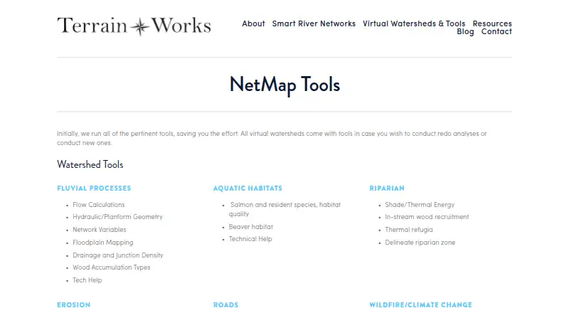
- Covers fluvial, habitat, erosion, wildfire, climate, and riparian analysis
- Integrates with ArcMap, NHD, NHDPlus, and Google Earth
Where it doesn't
- Contact-sales purchasing requires an annual subscription
- ArcMap is required for the add-in tools
- Its environmental focus may exceed general GIS requirements
Our verdict on NetMap
NetMap is a watershed analysis and decision-support system from TerrainWorks Inc. It is designed for resource managers, conservation and restoration practitioners, researchers, consultants, and public agencies working at project, watershed, and landscape scales. The system combines virtual watershed datasets with tools for river networks, terrain, aquatic habitats, erosion, roads, wildfire, climate change, riparian zones, and watershed processes. It supports web and Windows environments through a hybrid cloud and desktop deployment model.
Its main strength is analytical depth within environmental and watershed work. NetMap supports fluvial process analysis, flow calculations, floodplain mapping, aquatic and fish habitat analysis, erosion and landslide assessment, debris-flow and sediment-delivery analysis, and road-related drainage and stability analysis. It also covers wildfire probability, fire intensity, climate-change forecasting, riparian zones, shade, thermal energy, and wood recruitment. Watershed delineation, risk analysis, data management, and Google Earth export extend its use from individual analyses to broader planning workflows. The ArcMap add-in, along with NHD and NHDPlus integrations, makes the platform a fit for teams already working with those datasets and tools.
NetMap uses contact-sales pricing rather than a free plan. Licensing terms describe annual subscriptions, with costs dependent on users and datasets. TerrainWorks also provides online data visualization services and runs analyses for clients, which may suit organizations that need specialist support alongside the software. The product is a strong choice for environmental teams that need detailed watershed, fluvial, habitat, erosion, wildfire, or climate analysis. Organizations seeking a general-purpose GIS, or teams that do not work with ArcMap and watershed datasets, should consider a broader platform instead.
Your product? Our editors can test NetMap in depth and publish a review, labelled as paid · from $149/mo →
NetMap pricing
NetMap fact sheet
| Free plan | No |
|---|---|
| Paid from | Not verified |
| Deployment | Hybrid |
| Spatial analysis | Advanced |
| Web mapping | Not verified |
| Dashboard builder | Not verified |
| Raster data support | Yes |
| Mobile apps | Not verified |
| Deployment | Cloud, Desktop |
| Platforms | Web, Windows |
| Support | Email, Docs |
| Built for | Small business, Mid-market, Enterprise (editorial estimate) |
| Integrations | 4 integrations: ArcGIS ArcMap, NHD, NHDPlus, Google Earth |
| Pricing | Pricing on request |
| Website | terrainworks.com |
| Facts checked | 22 Sep 2026 |
NetMap integrations
NetMap lists 4 integrations on its own site.
- ArcGIS ArcMap
- NHD
- NHDPlus
- Google Earth
Alternatives to NetMap
- QGISA broad, no-cost GIS for advanced analysis, editing, mapping, and publishing.9.4
- GRASS GISA deep analytical GIS for technical teams that value open-source and scripted workflows.9.2
- Google Earth EngineA specialized GIS platform for large-scale satellite imagery, raster analysis, and geospatial computation.9.1



Used NetMap? Be the first to review it
The editor score above is our own research. What this page doesn't have yet is a reader's view — what you used NetMap for, what worked and what didn't. No stars are seeded and no review is paid for; an editor reads every one before it appears.
Write a reviewTwo minutes · verified accounts only · read by an editor before it appears
Featured on iTechGuides

NetMap is listed in our GIS Software directory. Add the badge to your site — it links back to this page.
<a href="https://www.itechguides.com/products/netmap/"><img src="https://www.itechguides.com/best/badge/netmap.svg" alt="Featured on iTechGuides" width="230" height="46"></a>
Reviewed by iTechGuides Editors · Editorial team · Updated Oct 2026
Advertiser disclosure: iTechGuides is reader-supported. Vendors can pay for top positions in our rankings and for a place on other products' pages, and we may earn a commission when you click some links. Bought places stand at the number bought; this page and our disclosure say so. Paying vendors may get a fuller, more detailed review from our editors, and that review can change their score. How we rank.
Last updated · How we research and update