
Latapult
Latapult: A parcel-focused GIS platform for site due diligence and development analysis. Ranked #23 of 36 in Location Intelligence Software by our editors (7.0/10); pricing: 7-day trial; best for parcel-focused site due diligence.
At a glance
- Editor score7.0 / 10
- Pricing7-day trial
- Best forParcel-focused site due diligence
- Free planNo
- Drive-time analysisYes
- Facts checked20 Sep 2026
Where it wins
- Combines parcel data with 250+ GIS datasets and spatial filters
- Supports buildable-area, travel-area, demographic, and census analysis
- Exports maps and reports while tracking due diligence and collaboration
Where it doesn't
- No free plan; access is paid after a 7-day trial
- Pricing is customizable, making plan-to-plan comparison less direct
- Web-only platform with a focus narrower than territory planning
Our verdict on Latapult
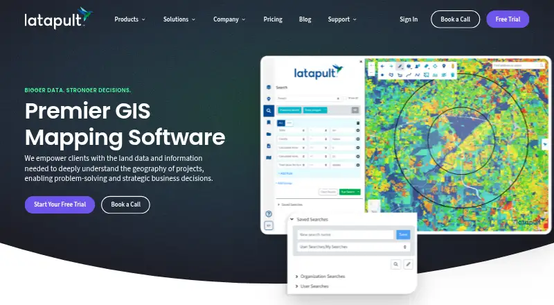
Latapult is a web-based GIS platform for land developers, site selectors, acquisition teams, engineers, utilities, and organizations evaluating property and development opportunities. Its core workflow combines parcel and ownership searches with environmental, demographic, infrastructure, zoning, transportation, and other GIS layers. Users can filter parcels, assess buildable areas and driving or walking travel areas, import external data, create reports, and coordinate due diligence. It is best suited to teams whose work starts with a parcel and moves toward site selection or development decisions.
Its ecosystem fit is a central strength. Latapult supports data imports and live web services, with listed formats including DWG, SHP, KML, and CSV. It also connects with CRM systems, CAD, ArcGIS, QGIS, and GIS web services. The Regions plan covers property intelligence, smart land searches, 250+ GIS datasets, exports, imports, and buildable-area analysis. Regions Plus adds editable data layers, advanced symbology and styling tools, and increased data storage. Custom Enterprise extends the platform with custom GIS layers and workflows, configurable data pipelines and automation, spatial document management, and dedicated GIS experts.
Pricing is paid rather than free, with a 7-day trial. The pricing page presents customizable packages for individual users or teams of 3, 5, or 10 people, with published starting prices for Metro coverage. That structure may suit organizations with defined GIS requirements, while buyers seeking a simple self-serve plan comparison may find it less straightforward. Latapult is a strong fit for parcel research, spatial analysis, and development due diligence. Organizations primarily seeking territory planning should consider a product centered on that workflow instead.
Your product? Our editors can test Latapult in depth and publish a review, labelled as paid · from $149/mo →
Latapult pricing
All 3 Latapult plans and prices →
Latapult fact sheet
| Free plan | No |
|---|---|
| Paid from | Not verified |
| Drive-time analysis | Yes |
| Territory planning | Not verified |
| Demographic data | Yes |
| Data upload formats | DWG, SHP, KML, CSV |
| API access | Not verified |
| Included user limit | 1 users |
| Free trial | 7 days |
| Deployment | Cloud |
| Platforms | Web |
| Support | Docs |
| Built for | Small business, Mid-market, Enterprise (editorial estimate) |
| Integrations | 5 integrations: CRM systems, CAD, ArcGIS, QGIS, GIS web services |
| Pricing | 7-day trial (source) |
| Website | latapult.com |
| Facts checked | 20 Sep 2026 |
Latapult integrations
Latapult lists 5 integrations on its own site.
- CRM systems
- CAD
- ArcGIS
- QGIS
- GIS web services
Alternatives to Latapult
- MaptitudeA broad location-analysis suite for established teams that need desktop and online GIS.9.3
- CARTOBroad spatial analytics, mapping, APIs, and deployment options for cloud-native teams.9.2
- GeoplanA mature web platform for route, territory, site and field-operation planning.9.0


See all Latapult alternatives →
Used Latapult? Be the first to review it
The editor score above is our own research. What this page doesn't have yet is a reader's view — what you used Latapult for, what worked and what didn't. No stars are seeded and no review is paid for; an editor reads every one before it appears.
Write a reviewTwo minutes · verified accounts only · read by an editor before it appears
Featured on iTechGuides

Latapult is listed in our Location Intelligence Software directory. Add the badge to your site — it links back to this page.
<a href="https://www.itechguides.com/products/latapult/"><img src="https://www.itechguides.com/best/badge/latapult.svg" alt="Featured on iTechGuides" width="230" height="46"></a>
Reviewed by iTechGuides Editors · Editorial team · Updated Oct 2026
Advertiser disclosure: iTechGuides is reader-supported. Vendors can pay for top positions in our rankings and for a place on other products' pages, and we may earn a commission when you click some links. Bought places stand at the number bought; this page and our disclosure say so. Paying vendors may get a fuller, more detailed review from our editors, and that review can change their score. How we rank.
Last updated · How we research and update