
GeoDesk
GeoDesk: A focused, developer-oriented spatial engine for querying OpenStreetMap data locally. Ranked #4 of 39 in Spatial Databases by our editors (8.7/10); pricing: Free plan; best for openStreetMap-based spatial applications.
At a glance
- Editor score8.7 / 10
- PricingFree plan
- Best forOpenStreetMap-based spatial applications
- Free planYes
- Paid fromFree
- Deployment modelSelf_hosted
- Facts checked20 Sep 2026
Where it wins
- Free, open-source engine for OpenStreetMap PBF data
- GOQL supports tags, bounding boxes, and spatial relationships
- Python, Java, and C++ libraries with broad output formats
Where it doesn't
- Focused on OpenStreetMap PBF data rather than general spatial sources
- No verified raster or 3D support
- Uses GOQL rather than SQL or a document-query interface
Our verdict on GeoDesk
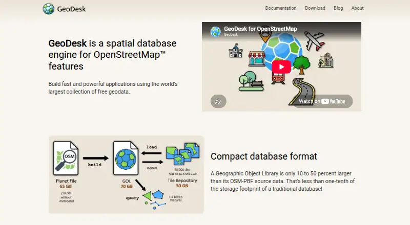
GeoDesk is an open-source spatial database engine for developers building geospatial applications and analyzing OpenStreetMap data. It stores OpenStreetMap features in Geographic Object Libraries, compact local database files designed for spatial queries. Developers can build and query these libraries with the gol command-line utility or use Python, Java, and C++ libraries. The product runs on Windows, macOS, Linux, and through an API, with support for points, linestrings, linearrings, polygons, multipoint, multilinestring, multipolygon, and geometry collection data.
The published offering is free and open source, with a self-hosted deployment model rather than a hosted service. Setup centers on creating Geographic Object Libraries from OpenStreetMap PBF data, then querying those local files. GOQL provides a MapCSS-like approach based on feature types, tags, bounding boxes, and spatial relationships. Interactive query mode and browser-based map visualization can help developers inspect results, while output options include GeoJSON, WKT, CSV, XML, PBF, and other formats. Coordinate conversion between WGS-84 and Mercator projections is also supported.
GeoDesk’s strongest fit is a focused OpenStreetMap workflow that needs local spatial querying and developer control. Geometry operations extend through Shapely and the Java Topology Suite, and the available libraries support several programming environments. That focus is also the main boundary: teams needing raster processing, 3D support, or a broader spatial database for sources beyond OpenStreetMap should choose an alternative. GeoDesk is a sensible choice for applications built around OpenStreetMap PBF data, especially when open-source deployment and multiple output formats matter.
Your product? Our editors can test GeoDesk in depth and publish a review, labelled as paid · from $149/mo →
GeoDesk pricing
GeoDesk fact sheet
| Free plan | Yes |
|---|---|
| Paid from | Free |
| Deployment model | Self_hosted |
| Query interface | Not verified |
| Spatial data types | point, linestring, linearring, polygon, multipoint, multilinestring, multipolygon, geometry collection |
| Raster support | Not verified |
| 3D geometry support | No |
| Coordinate transforms | Yes |
| Deployment | Self-hosted |
| Platforms | Windows, macOS, Linux |
| Support | Docs, Community |
| Built for | Solo, Small business, Mid-market, Enterprise (editorial estimate) |
| Integrations | 2 integrations: Shapely, Java Topology Suite |
| Pricing | Free plan |
| Website | geodesk.com |
| Facts checked | 20 Sep 2026 |
GeoDesk integrations
GeoDesk lists 2 integrations on its own site.
- Shapely
- Java Topology Suite
Alternatives to GeoDesk
- Oracle SpatialA broad SQL-based spatial capability for enterprise Oracle database deployments.9.4
- GeoMesaA self-hosted spatial engine for distributed, high-volume spatio-temporal workloads.9.2
- rasdamanA focused spatial database for querying, processing, and serving large raster datasets.9.0

See all GeoDesk alternatives →
GeoDesk vs the competition
- GeoDesk vs Oracle Spatial
- GeoDesk vs GeoMesa
- GeoDesk vs rasdaman
- GeoDesk vs Tile38
- GeoDesk vs SedonaDB
- GeoDesk vs IBM Informix


Compare GeoDesk with any tool side by side →
Used GeoDesk? Be the first to review it
The editor score above is our own research. What this page doesn't have yet is a reader's view — what you used GeoDesk for, what worked and what didn't. No stars are seeded and no review is paid for; an editor reads every one before it appears.
Write a reviewTwo minutes · verified accounts only · read by an editor before it appears
Featured on iTechGuides

GeoDesk is listed in our Spatial Databases directory. Add the badge to your site — it links back to this page.
<a href="https://www.itechguides.com/products/geodesk/"><img src="https://www.itechguides.com/best/badge/geodesk.svg" alt="Featured on iTechGuides" width="230" height="46"></a>
Reviewed by iTechGuides Editors · Editorial team · Updated Oct 2026
Advertiser disclosure: iTechGuides is reader-supported. Vendors can pay for top positions in our rankings and for a place on other products' pages, and we may earn a commission when you click some links. Bought places stand at the number bought; this page and our disclosure say so. Paying vendors may get a fuller, more detailed review from our editors, and that review can change their score. How we rank.
Last updated · How we research and update