
Do these 3 things before closing this tab:
1Repair Windows errors before they cause bigger problems2Fix the driver behind crashes, sound loss and screen glitches3Clear out junk files and repair common Windows errorsiTechGuides is reader-supported. When you buy through links on our site, we may earn an affiliate commission. As an Amazon Associate I earn from qualifying purchases. Learn more
Map every operating site and material supplier to a precise location, then screen those locations against biodiversity-sensitive areas and wider nature criteria. Treat the result as a prioritisation map—not proof that your company caused harm. A defensible process combines a georeferenced site inventory, biodiversity datasets, sector and commodity screening, supplier engagement, local validation and explicit uncertainty reporting.
What “biodiversity hotspots” means for a business map
“Biodiversity hotspot” is useful shorthand, but it has no single operational definition for corporate decisions. A map limited to protected areas can miss important habitat, threatened species, water stress and ecosystem services. The Taskforce on Nature-related Financial Disclosures (TNFD) uses a broader sensitive-location concept. Its definition covers “Areas important for biodiversity, including species and/or Areas of high ecosystem integrity and/or Areas of rapid decline in ecosystem integrity and/or Areas of high physical water risks and/or Areas of importance for ecosystem service provision, including benefits to Indigenous Peoples, Local Communities and stakeholders.”
Choose the criteria that match the decision you are making. A procurement screen may begin with protected areas, Key Biodiversity Areas (KBAs) and threatened-species information. A TNFD-oriented assessment also needs ecosystem integrity, rapid ecosystem decline, physical water risk and ecosystem-service importance. The absence of a mapped protected area does not establish that a location has low biodiversity importance or low nature risk.
The Tool Desk
Outbyte PC Repair FREEClear out junk files and repair common Windows errorsFree Scan →Outbyte Driver Updater FREEFix the driver behind crashes, sound loss and screen glitchesFind Drivers →Decide the boundary before collecting coordinates
Write down what the exercise is intended to support. Typical purposes include risk triage, site selection, procurement due diligence, target setting, lender or investor information, and nature-related reporting. The purpose determines the level of detail, the supplier tiers and the criteria you need.
#1 Best Overall
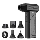
- Powerful Turbo Fan:CAGIWIRU Electric Air Duster have reached speed up to 130000RPM,Can efficient remove dust and debris.With LED light and Three Adjustable Speed to meet with different cleaning tasks.
- With Attached USB C Fasting Charging cable.Charing 3 hours,Enjoy up to 240 minutes of use on the lowest setting, For third speed can use for 25mins.with four charging options to meet with your needs.
- Wide Application: attached 5 different nozzles,making it suitable for a variety of scenes, such as car,pet, pc, keyboards, and other electronic devices. It also serves for office and home clean duster.
- Handy Design & Portable:Cordless air duster electric nozzle is Light weight and small size, design and comfortable to hold and space saving, convenient to carry around. You can put it in your room or inside the car without taking up space.
- Economical &Reusable: Built durable materials with a long-lasting battery,our CAGIWIRU air duster it's a sustainable alternative to disposable air cans.
Set organisational and geographic scope
- List the business units, legal entities, operating countries and facilities included.
- Define whether “operations” includes offices and warehouses or only production, extraction, farming, logistics and processing sites that can create material pressures on nature.
- Set a supplier boundary by tier. Start with direct suppliers and material upstream activities; explain separately what is excluded downstream.
- Identify commodities and services that could create significant land, freshwater, marine, pollution, climate or resource-use pressures.
- Record the reason for every inclusion and exclusion so the map is reproducible.
Choose the location unit
Use the physical place where an activity occurs, not merely a corporate mailing address. Keep headquarters, production facilities, farms, mines, mills, plantations, ports, warehouses and raw-material origins as separate location types. A supplier’s country-level address is not equivalent to a coordinate for the facility or source area that supplies your product.
Build a georeferenced operations and supplier inventory
Create one controlled inventory before opening a biodiversity map. Give each record a stable identifier and preserve the evidence used to place it. Store coordinates in a consistent reference system, or store a boundary polygon when a point would hide the scale of a farm, mine, forest concession or processing complex.
Minimum fields for direct operations
- Stable site ID and site name.
- Legal entity and business unit.
- Latitude and longitude, or a boundary geometry.
- Location precision, such as exact facility, approximate facility, municipality, region or country.
- Activity and operating status, including production, extraction, processing, storage, office or closed site.
- Location source, source date and the person or system that verified it.
- Relevant permits, production volume or other internal materiality indicator.
Additional fields for suppliers and upstream sources
- Supplier identity, relationship owner and tier.
- Product, service, commodity and relevant material.
- Production facility, farm, mine, mill, vessel, warehouse or other physical location type.
- Known sourcing country, region, watershed or concession.
- Whether the location is a supplier headquarters, production site or raw-material origin.
- Traceability evidence and the date it was received.
- Confidence rating and missing fields.
Do not overwrite uncertain information with a false point. Preserve the original country or region, the inferred geometry and the confidence level. A later supplier response should update the record while retaining an audit trail of what was previously known.
What’s actually slowing this PC down?
Pick the symptom - the matching free tool is one click away.
A practical confidence scale
| Confidence | Evidence | How to use it |
|---|---|---|
| High | Verified facility coordinate or boundary supplied by the operator and checked against an independent source. | Use for site-level screening, subject to dataset and date limitations. |
| Medium | Reliable facility address or municipality converted to an approximate point; activity is confirmed. | Use as a screening lead and request a more precise location. |
| Low | Country, broad region, spend category or sector estimate with no facility evidence. | Use only for regional or sector prioritisation, never as a precise supplier-site map. |
Screen locations for biodiversity-sensitive areas
Screen both the site geometry and an explicitly documented surrounding buffer. The appropriate distance depends on the activity, the ecological feature and the pressure pathway. A small factory footprint may be screened differently from a watershed-dependent mine, an agricultural sourcing area or a linear transport corridor. Record the buffer, threshold and screening date with every result.
Start with protected areas, KBAs and species information
IBAT provides access to protected-area, KBA and IUCN Red List-derived layers and supports site-specific and multi-site screening. Its integrated map can provide a rapid visual screen and biodiversity reports or GIS data access, depending on the service used. Use it to identify overlap, proximity and relevant biodiversity features, then investigate the underlying evidence.
A point outside a boundary can still affect a sensitive area through water abstraction, sediment, pollution, noise, invasive species, roads or supply-chain land conversion. Conversely, a point inside a mapped area does not by itself prove an adverse impact. Treat each flag as a question for operational and ecological assessment.
Rank #2

- Screen Cleaner is Your Screen’s New Bestfriend! - EVEO is proud to present a screen cleaner that’s perfectly suited for your TV. Meet your new screen cleaner, computer screen cleaner, laptop cleaner, iPad cleaner, Macbook,tv cleaner or any other electronic device. Our screen cleaner spray and wipe along with the included plush microfiber cloth, easily removes dust, fingerprints & other smudges on the screen’s surface. Clean effectively for a streak-free screen
- Gentle on your Screens - Our screen cleaner spray and wipes is compatible to be used even for the most sensitive LCD, LED, CRT, and OLED screens in proper use. Be at ease knowing that this product is compatible with all the major brands: LG, SONY, Samsung, Sharp, iPad, iPhone, Android screens, Kindle, PC monitors - we’ve got you covered! Can be used as LCD screen cleaner, tv cleaner, smart tv screen cleaner, and more
- Premium Super Soft Plush Microfiber Cloth - Included in this efficient screen cleaning kit. This screen cleaner spray and wipe has our signature plush microfiber cloth specially designed to comply with screens and monitors and leave them streak-free. Has been shown to effectively absorbs stubborn stains, zero streaks, and no fiber shedding. Always use this together with our screen cleaner for the best results
- Easy-to-Use Screen Cleaner Kit + microfiber cleaning cloth - The EVEO Screen Cleaning Kit will easily be your new favorite tool when it comes to taking care of the things you love most, quick and easy solution for a streak-free screen. Simply screw on the sprayer gun on the screen cleaner bottle. Spray the cleaning liquid onto the microfiber cloth, then wipe the screen until desired cleanliness & shine is achieved.
- Quality Screen Care Kit Worth Purchasing - Enjoy a convenient Screen Cleaner anytime, anywhere you need it. Your satisfaction is our top priority. We stand behind the quality of our products and that’s why, you shouldn’t be worrying at all. We manufacture the Best Screen Cleaner. and can be used for laptop cleaning kit, laptop screen cleaner, tv screen cleaner for smart tv. MacBook screen cleaner, monitor cleaner or screen cleaner spray for electronic devices with microfiber cleaning cloth
Add the broader TNFD-sensitive-location criteria
If your objective is a TNFD sensitive-location assessment, add methods or layers for:
- High ecosystem integrity.
- Rapid decline in ecosystem integrity.
- High physical water risk.
- Ecosystem-service provision, including benefits important to Indigenous Peoples and local communities.
- Biodiversity importance, including species and habitat features.
IBAT’s disclosure explanation notes that its current sensitive-site assessment focuses on biodiversity-importance criteria. Therefore, an IBAT result should not be presented as a complete screen of every TNFD criterion without additional datasets or analysis.
Use sector and commodity tools when supplier coordinates are missing
Most companies cannot immediately obtain precise locations beyond tier-one suppliers. Sector and commodity tools can narrow the search while you improve the inventory, but they do not substitute for facility evidence.
| Tool or resource | Useful role | Important limitation |
|---|---|---|
| IBAT | Site and multi-site screening using protected-area, KBA and IUCN Red List-derived information; biodiversity reports and GIS access. | A rapid map is not a complete biodiversity-risk assessment. Its current sensitive-site explanation focuses on biodiversity importance rather than every broader TNFD criterion. |
| ENCORE | Screening dependencies and impacts associated with sectors and activities, including upstream value-chain contexts. | It is not a supplier-coordinate database or a facility-level measurement of actual impact. |
| WWF Biodiversity Risk Filter | Corporate and portfolio-level prioritisation across value-chain stages and regions. | Confirm the current scope, indicators and outputs in WWF documentation before describing a specific feature as available. |
| Supplier disclosures and engagement | Obtaining facility coordinates, sourcing areas, tier information, traceability evidence and existing controls. | Coverage and precision depend on supplier willingness and the quality of their records. |
Compare tools on geographic resolution, value-chain coverage, biodiversity and broader nature criteria, dataset vintage, buffer choices, supplier-location capability, portfolio or GIS handling, method transparency and the distinction between screening and assessment. The available evidence does not establish a current like-for-like pricing or accuracy comparison.
How do I map my suppliers to biodiversity hotspots?
- Export the supplier master. Include supplier name, tier, product or service, commodity, business owner, spend or volume materiality and known country or region.
- Separate physical locations. Replace a headquarters address with production facilities, farms, mines, mills, warehouses and known source areas wherever those differ.
- Request missing evidence. Ask for facility coordinates or boundary files, sourcing regions, raw-material origins, traceability documents and the date each location was last verified.
- Assign confidence. Mark each record as high, medium or low confidence and retain the reason.
- Screen the available geometry. Run protected-area, KBA and species screens for precise sites; use country, region, sector and commodity information only as interim prioritisation.
- Overlay activity pressure. Connect the supplier’s activity to likely land, freshwater, marine, pollution, resource-use and climate pressures.
- Rank the follow-up. Combine ecological sensitivity, activity materiality, geographic confidence and potential pressure pathways.
- Engage priority suppliers. Validate coordinates, ask about biodiversity controls and request upstream locations where the risk depends on a deeper tier.
- Update and document. Record screening date, datasets, buffers, assumptions, unresolved gaps and the next review date.
Prioritize flagged locations without overstating the result
A useful prioritisation keeps three ideas separate: data coverage, ecological sensitivity and business pressure. A location with excellent coordinates and a KBA overlap may deserve urgent investigation. A supplier with only a country-level origin in a biodiversity-rich region may also deserve attention, but the evidence is less precise. A low screening score can reflect missing data rather than low risk.
Free tools Windows power users keep installed
One-click scans. No signup required.
Questions to ask for each flagged site
- What activity actually occurs at the location?
- Which biodiversity or nature criterion generated the flag?
- Is the site overlapping, adjacent to or merely in the same broad region as the sensitive area?
- What pressure pathways connect the activity to nature?
- Could impacts occur downstream through water, pollution, roads, sourcing or ecosystem-service dependence?
- What rights holders, local communities and other stakeholders may be affected?
- What evidence would confirm or overturn the priority rating?
Keep the wording precise: “screened as requiring investigation” is different from “caused biodiversity loss.” A map identifies where to investigate; it does not establish causation, severity, legality or stakeholder consent.
Rank #3

- 【Large size】:Measuring 800 x 300 mm/ 31. 5×12 inches, which is wider and taller than others. Large mouse pad can perfectly fit your keyboard and mouse of any size, and there is also ample space for peripherals such as phones, tablets, etc.
- 【LED backlight mouse pad】:Blade Hawks RGB mouse pad provides 7 static modes and 7 dynamic modes will give you the options you are looking for. Power-off memory function remembers the last lighting mode you selected. The super glow fiber Chroma will give you a colorful gaming setup that you want.
- 【Anti-slip rubber base】:Made from Natural rubber, this gaming mousepad will firmly grip your desktop, allowing you to enjoy the ultimate precision in the games you are most passionate about. It also comes with a texture that enhances this ability even further.
- 【Smooth and waterproof surface】: Micro-textured cloth surface, for extremely precise mouse control and a smooth movement. When liquid splashes on the gaming mouse pad, it forms water droplets and slides down. Will not delay your work or gameplay.
- 【Plug and play】: This mouse and keyboard pad is powered by USB, plug and play, no driver required. One button control light modes. Press one time to change the lighting mode, press twice to change the brightness, press and hold about 3 seconds turn ON/OFF.
Validate with suppliers, local experts and rights holders
For high-priority locations, ask suppliers to confirm the coordinate, boundary, activity, operating dates, source areas and mitigation measures. Request evidence such as traceability records, environmental permits, habitat-management plans, water-risk assessments, restoration commitments and grievance or consultation records where relevant.
Coordinates should be checked against the actual activity, not accepted solely because they geocode successfully. A point can represent a sales office, an administrative center or a town centroid. Qualified local experts can clarify ecosystem condition, seasonal water use, species presence and the meaning of a mapped boundary. Engage affected Indigenous Peoples, local communities and other stakeholders in ways appropriate to the location and decision; their knowledge and rights cannot be inferred from a global dataset.
A worked example: tracing a plant-fibre supply chain
A TNFD/IBAT case study describes assessing operational and supply-chain interfaces, tracing a supplier into its supporting industry supply chain and identifying a plant-based fibre sector signal across nine biodiversity-rich countries, including Brazil, Indonesia and Tanzania. The case used the signal to guide supplier engagement about timber sourcing and biodiversity-risk management, then sought upstream locations and mitigation information for high-risk sectors such as textiles.
This is an example of staged investigation, not a universal exposure estimate or a quantified performance result. The lesson is to move from a sector and country lead to supplier-specific evidence, then to site-level validation and action.
Align the workflow with current TNFD LEAP guidance
The current TNFD guidance page lists LEAP v2.0, published in October 2026. LEAP stands for Locate, Evaluate, Assess and Prepare:
- Locate: identify where the organisation and its value chain interface with nature, including operational sites and material upstream activities.
- Evaluate: determine dependencies and impacts associated with the activities and locations.
- Assess: analyse nature-related risks and opportunities, considering severity, likelihood, time horizon and affected stakeholders.
- Prepare: decide responses, targets, governance, monitoring and reporting.
LEAP is a workflow, not an automatic compliance certificate. A map, screening score or purchased report does not demonstrate that an organisation completed all four phases or met a particular disclosure obligation. Keep the evidence for each phase and explain where estimates, missing tiers or broader criteria remain unresolved.
Rank #4

- 【Softer and More Comfortable】Vaydeer wrist rest has unique diamond pattern, which is the combination of softness and aesthetics. The materials of wrist rest are improved into higher quality memory foam and covered with silky smooth lycra. The computer wrist rest makes you as comfortable and cushiony as like rest your wrists on clouds.
- 【Ergonomic Wrist Saver】The wrist rests for keyboard and mouse comes with a 17.32×3.15×0.83 inch keyboard wrist pad and a 5.94×3.15×0.83 inch mouse wrist support. Based on ergonomic design, the unique concave shape is the perfect fit for your wrist joints. The wrist rest pad fits most computer keyboards and laptops, improve hand and wrist posture, release your wrist and arm stress.
- 【Non-Slip Rubber Bottom】Featuring an anti-skid silicone base on the bottom, this wrist keyboard support stays firmly in place on your desk, preventing the padding from sliding around, ensuring stable and consistent wrist support during extended computer sessions.
- 【Better Experience & Pain Relief】Our keyboard arm rest is beneficial to alleviate the soreness caused by direct contact and friction between your arm and a hard desk surface, reducing the risk of wrist fatigue or carpal tunnel. The soft texture of memory foam can evenly distribute the pressure around your wrists and provide good support with just enough give.
- 【Helpful in Multiple Scenarios】Whether you're working, studying, writing, typing, gaming, this keyboard and mouse rest combo is an essential accessory to add comfort and support to your hands and wrists. It’s also a great gift for men, women, family, friend, coworker, gamer, teacher, etc.
Report uncertainty so readers can interpret the map
Every map, dashboard or disclosure should state:
- Which operations, suppliers, tiers, commodities and geographies were included.
- Whether locations are exact points, polygons, approximate addresses, country centroids or inferred sourcing regions.
- The source and vintage of biodiversity, water and ecosystem datasets.
- Buffer distances, overlap rules, thresholds and treatment of linear or large-area sites.
- Which TNFD-sensitive-location criteria were assessed and which were not.
- The percentage or count of records at each confidence level.
- Missing supplier tiers, unverified source areas and assumptions used for interim screening.
- The screening date, owner and planned update cycle.
Do not describe spend-based, sector-based or country-based screening as a precise supplier-site map. Label those outputs as prioritisation leads and show how you will replace them with location evidence.
Crashes, No Sound, or Screen Glitches?
Random freezes, missing sound and display glitches usually trace back to one bad driver. Find and replace yours safely.Free scan · under a minutePC Slower Than It Used to Be?
A free scan shows the junk files, broken settings and background clutter dragging Windows down - then fixes them in one click.Free scan · Windows 10 & 11Common mistakes and how to correct them
Using only protected-area boundaries
Why it fails: Important habitat, threatened species, ecosystem decline and water risk can occur outside protected areas.
Correction: Add KBA, species, ecosystem-integrity, water-risk and ecosystem-service criteria appropriate to the decision.
Plotting supplier headquarters
Why it fails: The headquarters may have no connection to the production or extraction activity creating the nature pressure.
Correction: Keep headquarters separate and request facility, farm, mine, mill and source-area locations.
Quick wins for a faster PC:
Scan for outdated or missing drivers - takes under a minuteDriver Scan →Clear out junk files and repair common Windows errorsFree Scan →Treating proximity as proof of harm
Why it fails: A map cannot establish causation, pressure, magnitude or legal responsibility.
Best Value

- 【No Drill Mounted】Cable management tray can be assembled in as little as 3 minutes or less-simply. Side clips easily clampe the edge of desk, pass through the holes on the sides, and secure excess cables with baskets. Desk cable management supports inward or outward installation to meet your needs in different scenarios, and provides you with great convenience when collecting and organizing wires.
- 【Rubber Pad Protects Desk】Wire organizer under desk built-in soft rubber pads on the clamp protect your desk from scratches, so you will not damage your furniture or office.
- 【Sturdy and Beautiful】Cord management under desk is made of high-quality carbon steel and holds about 15 lbs. The wire basket has 2 holes on each side of the tray to enable your cables to pass freely. Cable baskets are suitable for desk thickness use from 0.4" to 2.4".
- 【Space Saving & Keep Organized】Desk cable management tray holds all your power cords, outlet strips, USB hubs and computer transformers hidden from your feet, and the data cables will not enter the vacuum cleaner to keep your desk clean and tidy. Desk wire organizer is also suitable for use in the kitchen and outdoors.
- 【Reduce Safety Risks】Cable tray under desk keeps all plugs away from your kids, no more worry about tripping. Using 2 holes wire tray saves extra space, helps you easily cabling and wire protection. The mesh design is not easy to accumulate dust, but avoids safety accidents caused by messy wires.
Correction: Use the flag to trigger activity-specific evaluation, local validation and stakeholder engagement.
Hiding uncertainty
Why it fails: A country centroid or sector estimate can look more precise than the evidence supports.
Correction: Publish confidence, geometry type, source date, assumptions and missing tiers alongside the result.
Recommended Free Tools
Calling a tool output a complete TNFD assessment
Why it fails: Tools cover different criteria and scales, and LEAP includes evaluation, assessment and preparation beyond locating.
Correction: Describe each tool’s role, combine complementary evidence and document the remaining LEAP work.
Turn the map into decisions
Use high-confidence, high-materiality findings to inform supplier engagement, sourcing decisions, site planning, mitigation, monitoring and disclosure. Set a review trigger for new facilities, commodity changes, supplier changes, major land-use changes, updated biodiversity datasets or credible stakeholder concerns. For each material site, retain the original geometry, screening outputs, validation record, decision, owner and follow-up date.
The strongest outcome is not the most colorful map. It is a traceable location inventory that shows what the business knows, what it has inferred, which nature criteria were applied, why a location was prioritised and what evidence or action comes next.
Quick Recap
Product prices and availability are accurate as of the date/time indicated and are subject to change. Any price and availability information displayed on Amazon at the time of purchase will apply.

