
Free tools Windows power users keep installed
One-click scans. No signup required.
iTechGuides is reader-supported. When you buy through links on our site, we may earn an affiliate commission. As an Amazon Associate I earn from qualifying purchases. Learn more
Developers turn a world bible into a playable open-world map by translating narrative ideas into spatial rules, validating a rough geography and traversal network, then layering terrain, biomes, authored landmarks, procedural detail, missions and runtime streaming. The bible is not a finished map. It becomes a production system that tells the team what can exist, where it can exist and how the player should move through it.
The most reliable teams treat design, art and technology as one loop: establish macro geography first, test movement and sightlines in a blockout, generate repeatable coverage under explicit rules, hand-author the spaces that carry narrative weight, and organize the result for memory and streaming before final polish.
What a world bible must provide before map production starts
A world bible usually mixes geography, history, factions, climate, economy, landmarks, visual references and story beats. That material becomes useful to a level team only after it is converted into constraints that can be placed on a map or checked during a playtest.
The Tool Desk
Outbyte PC Repair FREEClear out junk files and repair common Windows errorsFree Scan →Outbyte Driver Updater FREEScan for outdated or missing drivers - takes under a minuteDriver Scan →Extract spatial constraints
Create a structured design sheet for every region. Record its climate, elevation, dominant terrain, resources, faction control, settlement pattern, traversal risks, visual identity and required landmarks. Add mission dependencies and forbidden combinations. A statement such as “the player sees the capital from the valley” is a sightline requirement. “This faction controls the only pass” is a geography and progression requirement. “Wetlands surround the old ruins” is a biome-placement rule.
#1 Best Overall
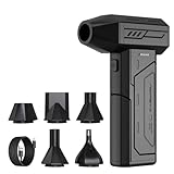
- Powerful Turbo Fan:CAGIWIRU Electric Air Duster have reached speed up to 130000RPM,Can efficient remove dust and debris.With LED light and Three Adjustable Speed to meet with different cleaning tasks.
- With Attached USB C Fasting Charging cable.Charing 3 hours,Enjoy up to 240 minutes of use on the lowest setting, For third speed can use for 25mins.with four charging options to meet with your needs.
- Wide Application: attached 5 different nozzles,making it suitable for a variety of scenes, such as car,pet, pc, keyboards, and other electronic devices. It also serves for office and home clean duster.
- Handy Design & Portable:Cordless air duster electric nozzle is Light weight and small size, design and comfortable to hold and space saving, convenient to carry around. You can put it in your room or inside the car without taking up space.
- Economical &Reusable: Built durable materials with a long-lasting battery,our CAGIWIRU air duster it's a sustainable alternative to disposable air cans.
Separate requirements into three categories:
- Must exist: capitals, passes, rivers, quest locations, faction strongholds and other elements required by story or progression.
- Must relate: visibility between landmarks, road connections, travel order, faction borders, supply routes and mission dependencies.
- Must not happen: contradictory climates, inaccessible objectives, impossible elevation changes or combinations that undermine the setting.
This translation exposes contradictions while the map is still cheap to change. It also gives technical artists and procedural designers machine-readable inputs instead of relying on memory or informal conversations.
Build the macro map before final assets
The first map is a diagram, not a finished environment. Place the major landmasses, coastlines, mountain barriers, rivers, roads, settlements, hubs and mission arcs. Mark the intended starting area, the major gates that control progression and the alternate routes that let players avoid or approach a challenge differently.
Check scale with a crude blockout
Use simple terrain, placeholder buildings and temporary markers. Walk or drive the routes with the movement abilities the game will actually ship with, rather than an editor camera. Check whether a journey feels like a short connection, a regional expedition or a major commitment. Test the order in which players encounter hubs and landmarks, and verify that a route blocked by a mountain, faction or story gate has a believable alternative when one is promised.
Windows Errors? Fix Them Before They Spread
Repair common Windows errors and clear accumulated junk for a smoother, more stable PC - no reinstall needed.Free scan · no reinstallCrashes, No Sound, or Screen Glitches?
Random freezes, missing sound and display glitches usually trace back to one bad driver. Find and replace yours safely.Free scan · under a minuteValidate landmark visibility at this stage. A capital that must dominate a valley may disappear once the terrain is raised; a supposedly secret facility may be visible from every road. Correct the ridgeline, valley width, settlement position or camera-facing approach before artists spend time on final geometry.
Use gates deliberately
Open-world maps need boundaries even when they appear seamless. A mountain pass, dangerous climate, faction checkpoint, traversal ability or mission state can control access. Each gate should have a readable reason and a route that supports the intended progression. If a later ability opens a shortcut, reserve the space for that shortcut in the macro layout rather than forcing it into finished terrain.
Rank #2

- Screen Cleaner is Your Screen’s New Bestfriend! - EVEO is proud to present a screen cleaner that’s perfectly suited for your TV. Meet your new screen cleaner, computer screen cleaner, laptop cleaner, iPad cleaner, Macbook,tv cleaner or any other electronic device. Our screen cleaner spray and wipe along with the included plush microfiber cloth, easily removes dust, fingerprints & other smudges on the screen’s surface. Clean effectively for a streak-free screen
- Gentle on your Screens - Our screen cleaner spray and wipes is compatible to be used even for the most sensitive LCD, LED, CRT, and OLED screens in proper use. Be at ease knowing that this product is compatible with all the major brands: LG, SONY, Samsung, Sharp, iPad, iPhone, Android screens, Kindle, PC monitors - we’ve got you covered! Can be used as LCD screen cleaner, tv cleaner, smart tv screen cleaner, and more
- Premium Super Soft Plush Microfiber Cloth - Included in this efficient screen cleaning kit. This screen cleaner spray and wipe has our signature plush microfiber cloth specially designed to comply with screens and monitors and leave them streak-free. Has been shown to effectively absorbs stubborn stains, zero streaks, and no fiber shedding. Always use this together with our screen cleaner for the best results
- Easy-to-Use Screen Cleaner Kit + microfiber cleaning cloth - The EVEO Screen Cleaning Kit will easily be your new favorite tool when it comes to taking care of the things you love most, quick and easy solution for a streak-free screen. Simply screw on the sprayer gun on the screen cleaner bottle. Spray the cleaning liquid onto the microfiber cloth, then wipe the screen until desired cleanliness & shine is achieved.
- Quality Screen Care Kit Worth Purchasing - Enjoy a convenient Screen Cleaner anytime, anywhere you need it. Your satisfaction is our top priority. We stand behind the quality of our products and that’s why, you shouldn’t be worrying at all. We manufacture the Best Screen Cleaner. and can be used for laptop cleaning kit, laptop screen cleaner, tv screen cleaner for smart tv. MacBook screen cleaner, monitor cleaner or screen cleaner spray for electronic devices with microfiber cleaning cloth
Establish terrain, drainage and traversal foundations
Once the macro arrangement works, build the terrain foundation. Landscape or heightfield tools define elevation, ridgelines, basins, slopes, passes and drainage. SideFX documents heightfields, erosion simulations and procedural terrain workflows that can feed engines such as Unreal or Unity. These tools are valuable because they let a team revise large landforms consistently instead of manually moving thousands of individual assets.
Shape terrain around play
Natural-looking terrain is not automatically playable terrain. Reserve slopes that match the movement system, provide staging areas before combat, and leave enough width for vehicles or companions if those systems exist. Rivers need crossings, banks and readable sources or destinations. Cliffs should communicate whether they are climbable, destructible or permanently blocking. Build collision and navigation assumptions into the blockout so level designers are not discovering basic access problems after dressing begins.
Recommended Free Tools
Review the terrain as a route network
Overlay roads, footpaths, water crossings, elevation bands and likely sightlines on the heightfield. Look for dead ends that have no design purpose, excessive backtracking and regions that are technically reachable but visually disconnected. A map can contain a large amount of land while offering too few meaningful choices; route density and landmark placement matter more than raw area.
Turn terrain into biome and settlement rules
Biomes should be defined as rules rather than painted decoration. Specify where forests, grasslands, deserts, wetlands, farms, roads and settlements may appear, along with transitions between them. Rules can use elevation, slope, moisture, distance from water, faction ownership and proximity to roads or ruins.
Define each biome’s identity
For every biome, document its dominant ground materials, vegetation families, rock shapes, weather cues, color range, ambient life and architectural language. Also define exclusions: a dense forest may avoid steep slopes and mission arenas; farmland may follow river terraces; a desert settlement may cluster around a reliable water source. These constraints prevent procedural dressing from erasing regional identity.
Rank #3

- 【Large size】:Measuring 800 x 300 mm/ 31. 5×12 inches, which is wider and taller than others. Large mouse pad can perfectly fit your keyboard and mouse of any size, and there is also ample space for peripherals such as phones, tablets, etc.
- 【LED backlight mouse pad】:Blade Hawks RGB mouse pad provides 7 static modes and 7 dynamic modes will give you the options you are looking for. Power-off memory function remembers the last lighting mode you selected. The super glow fiber Chroma will give you a colorful gaming setup that you want.
- 【Anti-slip rubber base】:Made from Natural rubber, this gaming mousepad will firmly grip your desktop, allowing you to enjoy the ultimate precision in the games you are most passionate about. It also comes with a texture that enhances this ability even further.
- 【Smooth and waterproof surface】: Micro-textured cloth surface, for extremely precise mouse control and a smooth movement. When liquid splashes on the gaming mouse pad, it forms water droplets and slides down. Will not delay your work or gameplay.
- 【Plug and play】: This mouse and keyboard pad is powered by USB, plug and play, no driver required. One button control light modes. Press one time to change the lighting mode, press twice to change the brightness, press and hold about 3 seconds turn ON/OFF.
Place settlements according to function
Settlements need an economic and strategic reason to occupy their location. A farming village should connect to arable land and a route to market. A fortress should control a pass, river crossing or coastline. A capital should have visible approaches, civic space and defensive logic. The bible’s faction and history entries provide the reason; the map must show the consequence.
Choose what is hand-authored and what is procedural
The boundary is player attention and authored intent, not a simplistic split between art and code. Hand-author spaces where pacing, narrative specificity or combat readability matter. Use procedural systems for broad, repeatable coverage, then curate their output with masks, exclusions and artist overrides.
| Content | Preferred method | Reason |
|---|---|---|
| Capital cities and faction strongholds | Hand-authored | Require unique identity, navigation, social layout and story staging. |
| Boss arenas, tutorial routes and quest interiors | Hand-authored | Need deliberate pacing, cover, encounter flow and objective readability. |
| Signature landmarks and landmark silhouettes | Hand-authored | Carry world recognition and guide long-distance navigation. |
| Vegetation, rocks and terrain breakup | Procedural with curation | Provide scalable coverage under biome, slope and density rules. |
| Roadside debris, secondary paths and repeated architecture | Procedural with overrides | Reduce repetitive manual placement while preserving access and composition. |
| Transitional areas between major locations | Hybrid | Rules establish continuity; designers correct awkward or over-generic results. |
GDC procedural-world material emphasizes the scale problem: a modern open world is too large for every square meter to receive equal attention from a level artist or designer. Procedural generation increases coverage, but it does not replace art direction, exclusion rules, landmark authorship or playtesting.
Make procedural output reproducible
Version the random seed, input masks, density limits, exclusion volumes and artist overrides. A designer must be able to regenerate the same result after a code or terrain change. Keep generated content separable from hand edits so a new road or mission space does not require destructive rework across the entire region.
Integrate missions, landmarks and traversal
Missions should be planned as a network over the geography, not dropped onto empty terrain after the map is complete. Mark objective locations, approach directions, escape routes, faction boundaries and required abilities on the macro map. Then test the sequence in the blockout.
Quick wins for a faster PC:
Clear out junk files and repair common Windows errorsFree Scan →Fix the driver behind crashes, sound loss and screen glitchesFind Drivers →Rank #4

- 【Softer and More Comfortable】Vaydeer wrist rest has unique diamond pattern, which is the combination of softness and aesthetics. The materials of wrist rest are improved into higher quality memory foam and covered with silky smooth lycra. The computer wrist rest makes you as comfortable and cushiony as like rest your wrists on clouds.
- 【Ergonomic Wrist Saver】The wrist rests for keyboard and mouse comes with a 17.32×3.15×0.83 inch keyboard wrist pad and a 5.94×3.15×0.83 inch mouse wrist support. Based on ergonomic design, the unique concave shape is the perfect fit for your wrist joints. The wrist rest pad fits most computer keyboards and laptops, improve hand and wrist posture, release your wrist and arm stress.
- 【Non-Slip Rubber Bottom】Featuring an anti-skid silicone base on the bottom, this wrist keyboard support stays firmly in place on your desk, preventing the padding from sliding around, ensuring stable and consistent wrist support during extended computer sessions.
- 【Better Experience & Pain Relief】Our keyboard arm rest is beneficial to alleviate the soreness caused by direct contact and friction between your arm and a hard desk surface, reducing the risk of wrist fatigue or carpal tunnel. The soft texture of memory foam can evenly distribute the pressure around your wrists and provide good support with just enough give.
- 【Helpful in Multiple Scenarios】Whether you're working, studying, writing, typing, gaming, this keyboard and mouse rest combo is an essential accessory to add comfort and support to your hands and wrists. It’s also a great gift for men, women, family, friend, coworker, gamer, teacher, etc.
Design for readable navigation
Give players a hierarchy of cues: a distant landmark for regional orientation, a road or natural corridor for local movement, and readable entrances for the immediate objective. Generated foliage or rock placement must not hide a required route, flatten a landmark’s silhouette or make every region use the same visual language.
Test the real movement kit
Run the map with the final or near-final walking, climbing, gliding, swimming, vehicle and fast-travel rules. Record where players stop, become disoriented, miss a gate or take an unintended shortcut. If a traversal ability changes the map’s topology, rebuild procedural masks and navigation data rather than patching individual locations indefinitely.
Organize the world for streaming and performance
Runtime organization is part of map design. A world that looks coherent in an editor can fail when memory, draw calls, collision, AI and navigation data are loaded together. Split the world into manageable runtime regions and decide which systems should load, unload or remain persistent as the player moves.
Use streaming boundaries that match play
Place region boundaries away from high-visibility vistas, combat arenas and locations where the player may turn around repeatedly. Coordinate terrain, foliage, buildings, audio, AI and mission state so a streamed region arrives with the data it needs. Test fast movement and abrupt direction changes; a boundary that works for walking may fail for vehicles or flight.
What’s actually slowing this PC down?
Pick the symptom - the matching free tool is one click away.
Generate hierarchical detail
Hierarchical Level of Detail reduces the cost of distant geometry by replacing many detailed objects with simpler representations. Epic’s open-world documentation identifies Hierarchical Level of Detail, Level Streaming, Landscape and Open World Tools as related parts of large outdoor-world production. Treat them as a coordinated setup: terrain chunks, distant buildings, vegetation and collision need compatible distance rules.
Best Value

- 【No Drill Mounted】Cable management tray can be assembled in as little as 3 minutes or less-simply. Side clips easily clampe the edge of desk, pass through the holes on the sides, and secure excess cables with baskets. Desk cable management supports inward or outward installation to meet your needs in different scenarios, and provides you with great convenience when collecting and organizing wires.
- 【Rubber Pad Protects Desk】Wire organizer under desk built-in soft rubber pads on the clamp protect your desk from scratches, so you will not damage your furniture or office.
- 【Sturdy and Beautiful】Cord management under desk is made of high-quality carbon steel and holds about 15 lbs. The wire basket has 2 holes on each side of the tray to enable your cables to pass freely. Cable baskets are suitable for desk thickness use from 0.4" to 2.4".
- 【Space Saving & Keep Organized】Desk cable management tray holds all your power cords, outlet strips, USB hubs and computer transformers hidden from your feet, and the data cables will not enter the vacuum cleaner to keep your desk clean and tidy. Desk wire organizer is also suitable for use in the kitchen and outdoors.
- 【Reduce Safety Risks】Cable tray under desk keeps all plugs away from your kids, no more worry about tripping. Using 2 holes wire tray saves extra space, helps you easily cabling and wire protection. The mesh design is not easy to accumulate dust, but avoids safety accidents caused by messy wires.
Profile the complete runtime
Measure memory, rendering, collision, AI, navigation and traversal systems in representative regions. Profile crowded hubs, dense forests, mission arenas and long sightlines, not only an empty test cell. When a region exceeds its budget, reduce expensive detail according to player visibility and interaction value instead of applying a uniform cut that damages landmarks or objectives.
Engine and tool choices
The right choice depends on how much control the team needs over authored spaces, how quickly it must cover large areas, the cost of generated content at runtime and how easily it can regenerate the world after a design change.
| Option | Documented capabilities or reference | Useful when |
|---|---|---|
| Unreal Engine | Landscape, Open World Tools, Level Streaming, Hierarchical Level of Detail and the Procedural Content Generation Framework. | The team wants integrated large-world authoring and runtime organization. |
| Unity | A GDC Vault session describes a small-team FPS open world using algorithmic content generation with Unity. | The team is evaluating procedural methods within a Unity workflow. |
| Houdini plus an engine | Heightfields, erosion, procedural assets and integration workflows for Unreal and Unity. | The team needs reusable terrain and content-generation tools that feed its runtime engine. |
Epic describes its Procedural Content Generation Framework as a toolset for creating procedural content inside Unreal Engine, built for extensibility and interactivity and able to integrate with existing world-building workflows. That makes PCG useful for a hybrid pipeline, where generated layers remain editable and responsive to authored changes.
Iterate as a living pipeline
After each major macro change, rebuild affected procedural layers, regenerate navigation and streaming data, and repeat focused reviews. Do not freeze the bible as a document that can no longer change. Treat it as a living set of constraints: when a mission changes the only pass, update faction control, roads, sightlines, settlement logic and procedural masks together.
Use separate reviews for geography and traversal, mission readability, visual identity, procedural quality and runtime performance. A generated result that looks attractive but blocks an objective is a design defect; a beautiful landmark that cannot be streamed reliably is a technical defect. Both belong in the same production loop.
Quick Recap
A practical handoff checklist
- Every region has climate, elevation, faction, economy, landmark and traversal rules.
- Major routes, gates, alternate approaches and mission dependencies are visible on the macro map.
- Terrain slopes, drainage, crossings and collision have been tested with real movement abilities.
- Biomes and settlements use explicit placement, transition and exclusion rules.
- Landmarks, hubs, boss arenas, tutorial routes and quest interiors have deliberate authorship.
- Procedural layers use versioned seeds, masks, density limits and artist overrides.
- Generated content has been reviewed for navigation, regional identity and mission readability.
- Streaming regions, hierarchical detail and runtime profiles cover hubs, wilderness and long sightlines.
- Macro edits trigger regeneration and focused design, art and performance reviews.
Product prices and availability are accurate as of the date/time indicated and are subject to change. Any price and availability information displayed on Amazon at the time of purchase will apply.

