
Crashes, No Sound, or Screen Glitches?
Random freezes, missing sound and display glitches usually trace back to one bad driver. Find and replace yours safely.Free scan · under a minuteWindows Errors? Fix Them Before They Spread
Repair common Windows errors and clear accumulated junk for a smoother, more stable PC - no reinstall needed.Free scan · no reinstallThe best offline map app for iPhone and iPad depends on the trip: Apple Maps is the simplest Apple-native choice, Google Maps is strongest for businesses and addresses, Organic Maps is the best free offline alternative, and OsmAnd, Gaia GPS, or Avenza Maps are better for hiking and specialty maps. No offline app preserves live traffic and every online feature.
Offline maps are most useful when you are travelling abroad, driving beyond cellular coverage, or heading into the countryside. The important question is not simply whether an app works “offline,” but whether the app can display maps, find places, calculate routes, navigate turn by turn, and provide the map layers you actually need without an internet connection.
Key takeaways
- Apple Maps supports offline map downloads on iOS 17 or later, but availability and offline features vary by region.
- Google Maps supports offline driving when the complete route remains inside the downloaded map area, but offline mode removes traffic, alternate routes, walking, cycling, and public-transit directions.
- Organic Maps is the clearest free-first option: its App Store listing describes free, ad-free offline search and navigation, unlimited map downloads, OpenStreetMap data, and iPhone and iPad support on iOS/iPadOS 15 or later.
- OsmAnd and Gaia GPS are better suited to technical outdoor planning, while Avenza Maps is designed around downloadable georeferenced maps.
- A Wi-Fi-only iPad may not have independent GPS/GNSS hardware, so iPad model and connectivity matter before relying on an iPad as a navigation device.
What are the best offline map apps for iPhone and iPad?
There is no single best offline map app for every iPhone and iPad owner. Use Apple Maps or Google Maps for ordinary city navigation, addresses, businesses, and driving; choose Organic Maps for a free and privacy-oriented general-purpose alternative; and choose OsmAnd, Gaia GPS, or Avenza Maps when hiking, backcountry planning, GPX files, topographic layers, or specialty maps matter more than restaurant search.
| App | Best for | Offline capabilities | Main limitation | Cost model |
|---|---|---|---|---|
| Apple Maps | Simple navigation for iPhone and iPad owners | Downloaded maps, with offline features depending on region | Requires iOS 17 or later; specialist outdoor coverage is limited | Included with Apple devices |
| Google Maps | Businesses, restaurants, addresses, and familiar city driving | Offline map display, place search, and driving navigation within the downloaded area | No offline traffic, alternate routes, walking, cycling, or public-transit directions | Free app; mobile data may incur carrier charges |
| Organic Maps | Free, ad-free, privacy-oriented offline navigation | Offline map display, search, and navigation; unlimited downloads according to its App Store listing | Business information may be less complete than Google’s | Free |
| HERE WeGo | International road travel | Offline road-navigation positioning should be evaluated for the destination countries | Country-specific coverage and online features need checking | Verify current app and service terms |
| OsmAnd | Power users, hikers, cyclists, and GPX planning | Configurable OpenStreetMap-based maps and outdoor workflows | More complicated interface; free and paid limits vary | Free and paid purchase paths |
| Gaia GPS | Backcountry recreation and layered outdoor maps | Downloaded outdoor map layers and saved-route workflows | Best features generally require a paid plan | Subscription-led; verify current plan |
| Avenza Maps | Georeferenced park, public-land, nautical, aviation, and specialty maps | Downloaded map files can be used offline | Quality and coverage depend on the individual map product | Free and paid maps |
What does “offline maps” actually mean?
“Offline” describes several different capabilities, and an app may support some without supporting all of them.
What’s actually slowing this PC down?
Pick the symptom - the matching free tool is one click away.
#1 Best Overall

- FAST & CLEAR DISTANCES See front, middle, and back of the green instantly, plus key hazards to plan every shot with confidence.
- 42,000+ COURSES WORLDWIDE Play anywhere with access to over 42,000 preloaded golf courses ready right out of the box.
- NO PHONE REQUIRED ON THE COURSE Works independently once the course is loaded—no need to carry your phone while you play.
- NO SUBSCRIPTION REQUIRED Pay once and enjoy lifetime access with free course updates.
- LIGHTWEIGHT & SUNLIGHT READABLE Comfortable for all-day wear with a high-contrast display that stays clear in bright sunlight.
| Capability | What it lets you do | What it does not guarantee |
|---|---|---|
| Offline map viewing | Pan and zoom through map data stored on the device | Current roads, closures, or business information |
| Offline GPS positioning | See the device’s location without cellular data | Reliable positioning indoors, underground, in tunnels, or under dense foliage |
| Offline place search | Find downloaded addresses, towns, businesses, landmarks, or trailheads | The same search depth, reviews, photos, phone numbers, or opening hours available online |
| Offline route calculation | Calculate a route from locally stored map data | Traffic-aware routing or every possible detour |
| Offline turn-by-turn navigation | Follow visual or spoken instructions on a calculated route | Live road closures, accidents, or changing traffic |
| Offline trail or map layers | Use hiking routes, contours, satellite imagery, or specialty maps saved locally | Every layer being available in every country or plan |
| Online-only services | Use live traffic, transit departures, reviews, Street View imagery, and continually updated business data | Availability after the connection disappears |
An iPhone or iPad can usually determine its position from GPS/GNSS without an internet connection, but the app must already contain the relevant map data and, where required, routing data. GPS is a positioning system; GPS does not download roads, places, trail data, traffic, or emergency information.
Which offline map app is best for ordinary driving?
Apple Maps is the simplest first choice for many iPhone owners, Google Maps is generally stronger for business and place discovery, and HERE WeGo is worth comparing for international road trips. The best choice depends on route coverage, search quality, CarPlay preferences, offline recalculation, and whether current traffic matters.
| Driving need | Most suitable starting point | Why | Important offline compromise |
|---|---|---|---|
| Native iPhone integration | Apple Maps | Already integrated into iOS and iPadOS | Offline availability and features vary by region |
| Restaurants, businesses, and addresses | Google Maps | Broad, familiar place database and strong search | Traffic, alternate routes, and several travel modes disappear offline |
| Cross-border road travel | Google Maps and HERE WeGo | Compare downloaded-country coverage and route behavior before departure | Coverage, place data, and online features vary by country |
| Privacy-oriented general navigation | Organic Maps | Offline-first, ad-free, OpenStreetMap-based workflow | Business data and routing detail may differ from Google’s |
Google Maps can provide offline driving guidance when the complete route remains within the downloaded map area. Google’s official instructions also state that offline mode does not provide traffic information or alternate routes, and that walking, cycling, and public-transit directions are unavailable offline. Google’s offline Maps documentation also warns that offline downloads may be unavailable in some countries or regions.
For iPhone and iPad, Google Maps currently requires iOS 16 or later according to Google’s system-requirements page.
How do you download an area in Google Maps on iPhone or iPad?
Download Google Maps data while connected to the internet, then test the saved area before travelling.
- Open Google Maps while connected to the internet.
- Search for a destination.
- Tap the location name or address.
- Tap More, then tap Download offline map.
- Tap Download.
You can also tap your profile picture or account initial, choose Offline maps, tap Select your own map, adjust the map area, and tap Download. Download a larger area than the visible destination if the route includes airports, border crossings, rural approaches, mountain passes, or likely detours.
Google says offline maps must be updated before they expire. When an offline map has 15 days or less remaining and the device is connected to Wi-Fi, Google Maps attempts to update the map automatically. Do not assume an old download contains current roads, businesses, or restrictions.
Is Apple Maps a genuine offline option?
Yes. Apple Maps supports offline map downloads on iOS 17 or later, but Apple presents offline availability and features as dependent on the supported region. Apple Maps also uses local device storage and shows the anticipated file size before a download.
The Tool Desk
Outbyte Driver Updater FREEFix the driver behind crashes, sound loss and screen glitchesFind Drivers →Outbyte PC Repair FREEClear out junk files and repair common Windows errorsFree Scan →To prepare Apple Maps, connect to Wi-Fi, search for a place or display the relevant area, then use the offline-map download control offered by Maps for that place or map area. Apple’s documentation covers downloading from a place search, dropped pin, or current map view. Apple’s offline Maps support page explains the iOS requirement, storage behavior, regional limitations, and available offline functions.
Check four things before relying on Apple Maps:
- Confirm that offline maps are available in your country or region.
- Confirm that the downloaded area covers the entire journey, including likely detours.
- Check whether driving, walking, cycling, or transit is supported offline for the destination region.
- Leave enough storage for photos, iOS updates, and other apps after the map download.
Apple Maps is a strong choice when the main priority is a simple Apple-native experience. Apple Maps is not automatically the best choice for remote trails, topographic layers, GPX-heavy planning, or specialty georeferenced maps.
Is Google Maps better than Apple Maps offline?
Google Maps is usually the better starting point for businesses, restaurants, addresses, and international familiarity, while Apple Maps is the more integrated choice for people who want to stay within the Apple ecosystem. Neither app retains all live online services after disconnection, and neither replaces a specialist outdoor mapping app.
| Comparison | Apple Maps | Google Maps |
|---|---|---|
| Best reason to choose it | Native iPhone and iPad integration | Business, restaurant, and address discovery |
| Offline requirement | iOS 17 or later; supported region | Downloaded map area; iOS 16 or later |
| Offline driving | Supported where the region and downloaded map permit it | Supported when the complete route remains inside the download |
| Offline traffic | Do not expect live traffic after disconnection | Unavailable offline |
| Offline alternate routes | Region- and feature-dependent; test first | Unavailable offline |
| Offline walking, cycling, and transit | Support varies by region and mode | Walking, cycling, and public-transit directions unavailable offline |
| Storage information | Apple shows the anticipated download size | Download size depends on the selected area |
Is Organic Maps genuinely free and offline?
Organic Maps is the strongest free-first recommendation for readers who want offline map display, search, and navigation without ads or a subscription requirement. Its current App Store listing describes Organic Maps as free, ad-free, OpenStreetMap-based, available for iPhone and iPad, and usable for offline search and navigation with unlimited map downloads; the listing indicates iOS/iPadOS 15 or later compatibility.
Organic Maps is particularly attractive for international travel, privacy-conscious users, hiking, cycling, and anyone who wants to download broad regions without paying for a premium map layer. OpenStreetMap detail can be excellent, especially where local contributors have mapped trails and minor roads carefully.
Organic Maps is not a universal replacement for Google Maps. Business listings, reviews, opening hours, phone numbers, and routing detail may be less complete or less current than Google’s data in some locations. Organic Maps also cannot provide live traffic when the device is offline. Map updates require occasional internet access, and GPS reception can still fail in tunnels, buildings, deep valleys, dense urban areas, or heavy foliage.
Which apps are best for hiking and backcountry use?
OsmAnd, Gaia GPS, and Avenza Maps are better outdoor choices than ordinary city-navigation apps when the trip depends on contour lines, trail data, GPX files, route recording, saved waypoints, or specialty map layers.
| Outdoor requirement | Best fit | What to look for | Trade-off |
|---|---|---|---|
| Customizable maps and GPX workflows | OsmAnd | OpenStreetMap data, configuration, GPX import/export, saved routes, and outdoor details | More technical interface and changing free-versus-paid limits |
| Multiple topographic and backcountry layers | Gaia GPS | Layer selection, route planning, downloaded maps, and saved tracks | Subscription requirements and included layers vary by plan and region |
| A particular park, public-land, nautical, or aviation map | Avenza Maps | Georeferenced files, map-store availability, offline location on the map | Each map product has its own coverage, quality, and cost |
| Simple free hiking navigation | Organic Maps | Offline trail and road data where OpenStreetMap coverage is adequate | Fewer specialist layers and less uniform trail detail |
What is OsmAnd best for?
OsmAnd is best for readers who want technical control over OpenStreetMap-based maps, outdoor details, GPX routes, and route-planning options. OsmAnd can suit hikers, cyclists, equestrians, and experienced users who are willing to configure map layers and download the correct regions.
Free tools Windows power users keep installed
One-click scans. No signup required.
OsmAnd’s iOS purchasing documentation explains how purchases can be restored across supported stores by linking them to an OsmAnd Cloud account. Check OsmAnd’s current iOS purchase documentation before publication or purchase because exact plan limits and pricing can change.
What is Gaia GPS best for?
Gaia GPS is best for backcountry recreation and layered outdoor mapping rather than ordinary city driving. Gaia GPS is a better fit when users need topographic or other outdoor layers, saved routes, track recording, and route planning away from cellular service.
Gaia GPS is not the best recommendation for someone who mainly needs restaurant reviews, business hours, live traffic, or automatic urban driving routes. Subscription requirements and included layers vary by plan and region, so check the current plan before paying.
What is Avenza Maps best for?
Avenza Maps is best when the reader already has, or wants to obtain, a particular georeferenced map. Avenza’s support material says maps downloaded to an iPhone or iPad can be used offline, and that the map store includes both free and paid maps. Avenza’s offline-map support material is the relevant reference for that workflow.
Avenza Maps is especially useful for park maps, public-land maps, nautical charts, aviation maps, and other products that are distributed as individual map files. Avenza Maps is a poor fit if the reader expects one worldwide basemap with uniform business search and automatic city-driving routes.
Rank #2
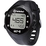
- ACCURATE DISTANCES, NO DISTRACTIONS: Get fast and accurate distances to the front, center, and back of the green, plus hazards and shot distance measurement. The ULT-G is designed for golfers who want reliable yardages without unnecessary complexity.
- NO PHONE REQUIRED ON THE COURSE: Ready to play right out of the box. The ULT-G works independently during your round, so there's no need to carry your phone. An optional companion app is available for free course and firmware updates.
- EASY TO USE: No complicated menus or touchscreen. Press the Satellite button to locate nearby courses, select your course, and start your round. With five intuitive buttons, a clear display, and automatic hole progression, getting accurate distances is quick and effortless.
- 38,000+ PRELOADED COURSES & NO SUBSCRIPTION FEES: Access more than 38,000 golf courses worldwide right out of the box. Enjoy free course updates and lifetime software support with no monthly fees or subscriptions required.
- LIGHTWEIGHT, RELIABLE & BUILT FOR GOLF: Comfortable enough to wear all day at only 55g. Water-resistant construction and a battery designed to last up to 2.5 rounds per charge. Includes a one-year warranty and responsive customer support.
Is HERE WeGo worth considering for international driving?
HERE WeGo is worth evaluating alongside Google Maps for offline road navigation across multiple countries, but country-specific coverage and current iPhone and iPad features should be checked before departure. Download the destination countries or regions, verify the available driving modes, and test a route with the device disconnected.
HERE WeGo should be treated as a driving-focused comparison rather than a hiking, specialty-map, or business-review recommendation. Readers who need live traffic, transit, local place discovery, or road-closure information should verify which services remain available online and which map data can be stored locally for each destination.
Independent reader supportYour contribution helps us test, update, and keep practical guides available for everyone.How should you prepare an iPhone or iPad for an offline trip?
Prepare and test the complete offline workflow before leaving connectivity; downloading a map is not the same as proving that navigation will work on the planned route.
Do these 3 things before closing this tab:
1Clear out junk files and repair common Windows errors2Fix the driver behind crashes, sound loss and screen glitches3Repair Windows errors before they cause bigger problems- Install and update the app. Update the app and the device while connected to reliable Wi-Fi.
- Download the whole area. Include the origin, destination, entire route, border crossings, airports, rural approaches, mountain passes, and likely detours.
- Save critical places. Save accommodation, trailheads, fuel stations, hospitals, campsites, transport hubs, and emergency meeting points before going offline.
- Download specialist layers or routes. For outdoor trips, save topographic layers and import GPX files before departure.
- Check storage. Apple Maps shows the anticipated file size before an offline download; other apps also vary by area, zoom level, detail, and layers.
- Test Airplane Mode. Turn on Airplane Mode, open the app, search for saved places, view the map, calculate a route, and confirm that the device location appears.
- Confirm the iPad’s positioning hardware. A Wi-Fi-only iPad may not have independent GPS/GNSS hardware. A cellular iPad may be better suited to independent positioning, but verify the exact model.
- Charge the devices. Bring a power bank or vehicle charger, reduce screen brightness when practical, and avoid continuous track recording unless needed.
- Carry a backup. Use a second downloaded device, a printed route, or a paper map for remote or consequential travel.
How much storage do offline maps use?
There is no universal offline-map file size because storage use depends on geographic area, zoom level, map detail, road and trail density, points of interest, downloaded layers, and whether satellite imagery or routing data is included. Check the proposed download size in the app instead of relying on a generic estimate.
Download only the areas needed for the trip, leave free storage for photos and operating-system updates, and use Wi-Fi for large downloads. Apple Maps explicitly shows the anticipated file size before downloading an offline map. Apple’s offline-map documentation describes that storage warning.
Will offline navigation work on an iPad?
Offline navigation on an iPad depends on both the map app and the iPad model. A Wi-Fi-only iPad may not include the same built-in GPS/GNSS hardware as a cellular iPad, so a Wi-Fi-only model may be unable to determine its independent live position even when downloaded maps are present.
A cellular iPad is generally the safer choice when the iPad itself must provide positioning, but exact capabilities depend on the model. An iPhone can sometimes provide connectivity or positioning while an iPad displays downloaded maps, although the connection and app behavior should be tested before travel.
Organic Maps explicitly supports iPhone and iPad according to its App Store listing. App compatibility does not by itself guarantee that every iPad has independent GPS/GNSS hardware.
What are the main offline-map failure modes?
Live information disappears
Offline maps generally cannot know about newly closed roads, accidents, temporary construction, transit delays, changed business hours, weather hazards, or emergency alerts. Downloaded data is a prepared snapshot, not a live connection.
The route leaves the download
A route can begin and end inside a downloaded region while briefly crossing outside it. Google explicitly requires the complete driving route to remain within the downloaded area for offline guidance. Download a buffer around the planned route rather than only the city or destination.
Offline search is weaker
A map can display roads while offline but still lack full business metadata, reviews, photos, phone numbers, opening hours, search synonyms, or recently added addresses. Save important places as favorites or pins before disconnecting.
Recommended Free Tools
GPS reception fails
GPS/GNSS can work without internet access, but positioning can become poor indoors, underground, in tunnels, between tall buildings, in deep valleys, or beneath thick forest. A moving blue location dot is not a guarantee that every route instruction is correct.
The battery runs out
Offline navigation can still consume substantial battery through GPS/GNSS, a bright display, voice guidance, continuous route recording, Bluetooth, and CarPlay. Carry a power bank or vehicle charger, and do not treat a phone as the only safety device in remote terrain.
The map is stale
OpenStreetMap-derived apps depend on local contributions and update schedules. Commercial providers may have better business data in some areas, while community mapping may offer more trail detail elsewhere. Update maps immediately before travel and check important roads or trails against an additional source.
Which offline map app should you choose?
| If your priority is… | Choose first | Consider adding |
|---|---|---|
| The simplest Apple-native setup | Apple Maps | Organic Maps for a second offline map |
| Businesses, restaurants, addresses, and reviews | Google Maps | Organic Maps or HERE WeGo for broader offline preparation |
| A completely free, ad-free offline alternative | Organic Maps | Google Maps for richer online business data |
| Privacy-oriented general navigation | Organic Maps | Apple Maps for Apple-device integration |
| Technical hiking, cycling, or GPX planning | OsmAnd | Gaia GPS for additional outdoor layers |
| Backcountry layers and saved outdoor routes | Gaia GPS | OsmAnd or a paper topographic map |
| A particular park, public-land, nautical, or aviation map | Avenza Maps | A general-purpose app for roads and businesses |
| International offline road travel | Compare Google Maps with HERE WeGo | Organic Maps as an additional downloaded map |
For most trips, a two-app strategy is more dependable than searching for one perfect app: use Apple Maps or Google Maps for city search and normal driving, then add Organic Maps, OsmAnd, Gaia GPS, or Avenza Maps for privacy, remote travel, outdoor routes, or specialty map layers.
Frequently Asked Questions
Can I use Google Maps completely offline on an iPhone?
Google Maps can provide offline driving navigation on an iPhone when the complete route is inside a downloaded map area. Offline Google Maps does not provide traffic, alternate routes, walking, cycling, or public-transit directions, and offline downloads may not be available in every country or region.
Which free offline map app is best for iPhone and iPad?
Organic Maps is the clearest free offline map recommendation for iPhone and iPad because its App Store listing describes free, ad-free offline map display, search, navigation, unlimited downloads, and OpenStreetMap data. Organic Maps may have less complete business information than Google Maps.
Does Apple Maps work offline on iPhone?
Apple Maps supports offline map downloads on iOS 17 or later in supported regions. Offline maps use device storage, and Apple Maps shows the anticipated download size before downloading; supported offline features can vary by region.
Can a Wi-Fi-only iPad use offline GPS maps?
A Wi-Fi-only iPad may not have independent GPS/GNSS hardware, so downloaded maps may work for viewing without allowing the iPad to determine its own live location. Check the exact iPad model or use a positioning-capable iPhone or cellular iPad, then test the app in Airplane Mode.
Quick wins for a faster PC:
Scan for outdated or missing drivers - takes under a minuteDriver Scan →Repair Windows errors before they cause bigger problemsFix Now →Fix the driver behind crashes, sound loss and screen glitchesFind Drivers →What is the best offline map app for hiking?
OsmAnd, Gaia GPS, and Avenza Maps are stronger hiking choices than ordinary city-navigation apps when you need topographic layers, GPX routes, track recording, waypoints, or georeferenced specialty maps. Organic Maps can be a useful free option where OpenStreetMap trail coverage is sufficient.
The Bottom Line
Bottom line: Choose Apple Maps for the simplest Apple-native experience, Google Maps for businesses and familiar city driving, Organic Maps for free ad-free offline navigation, OsmAnd or Gaia GPS for advanced outdoor planning, and Avenza Maps for downloaded specialty maps. Before leaving signal, download a route-sized area with a buffer, save critical places, test Airplane Mode, charge the device, and carry a backup for remote travel.
Quick Recap
Product prices and availability are accurate as of the date/time indicated and are subject to change. Any price and availability information displayed on Amazon at the time of purchase will apply.

