
Bing Maps APIs can support logistics workflows such as address lookup, route calculation, and multi-stop route optimization—but they are not a complete fleet-dispatch system, and a new integration needs to account for the service’s retirement timeline. Microsoft retired Bing Maps for Enterprise Basic accounts; Enterprise customers can continue using the services until June 30, 2028. Microsoft identifies Azure Maps as the migration destination.
What Bing Maps APIs can do for logistics
Bing Maps REST services accept URL-based requests and require a Bing Maps key. Microsoft’s REST service documentation covers location search, elevation, imagery, and routes. Route options include walking, driving, and transit; a separate truck route API calculates truck-specific routes.
- Location lookup: Search for locations as part of address-to-destination workflows.
- Route calculation: Request walking, driving, or transit routes, depending on the service and use case.
- Truck routing: Calculate a truck route where the service supports the deployment geography.
- Maps and related data: Request static maps or imagery metadata, or use elevation services. Microsoft also documents Bing Spatial Data Services, including bulk-geocoding context.
Microsoft’s example of an optimized route with multiple waypoints shows a route-planning use case for arranging stops. It does not establish that the APIs provide end-to-end dispatch, vehicle-capacity planning, driver scheduling, or every constraint a carrier may need. Treat those as application requirements to validate rather than built-in capabilities.
How to calculate a truck route
Microsoft documents a Bing Maps truck route API for truck-specific route calculation. The service is available only in certain countries and regions; the documentation cited here does not provide a region list. Before designing around truck routing, confirm coverage for each country where the application will operate and check the current API documentation for relevant road restrictions.
Quick wins for a faster PC:
Fix the driver behind crashes, sound loss and screen glitchesFind Drivers →Clear out junk files and repair common Windows errorsFree Scan →Scan for outdated or missing drivers - takes under a minuteDriver Scan →#1 Best Overall
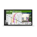
- 6” touchscreen truck navigator offers a bright, crisp high-resolution display
- Get custom truck routing (Not available in all areas. Vehicle characteristics may not be accounted for in all route suggestions. Defer to posted signs and road conditions.) based on the size and weight of your truck, and see alerts for upcoming bridge heights, weight limits, sharp curves, steep grades and more
- Leading-edge arrival planning with BirdsEye Satellite Imagery provides high-resolution aerial views of loading docks, truck entrances and security gates
- The route planner feature helps drivers review their complete routes and determine the best places for fuel stops, comfort breaks and overnight stays
- Truck & Trailer Services directory allows drivers to filter truck stops by brand or amenity, such as “Love’s” or “Showers”
- Confirm that truck routing is available in the required geography using Microsoft’s current truck-route documentation.
- Request the route through the truck route API, supplying the route information required by that API and a valid Bing Maps key.
- Validate the returned route against the operating constraints your application must enforce. Do not assume coverage or constraint handling beyond what Microsoft documents for the service.
Microsoft names the Azure Maps Route Directions API as the migration target for Bing Maps truck routing. Verify the Azure Maps service’s behavior and coverage for your use case rather than assuming the two APIs are one-for-one substitutes.
Availability: Basic accounts are retired; Enterprise runs through June 30, 2028
Microsoft Learn states that Bing Maps for Enterprise has been retired for all free Basic account customers. Enterprise customers can continue using Enterprise services until June 30, 2028. Microsoft says customers need to update their REST APIs and SDKs to Azure Maps by that date to avoid service disruption. The truck-route documentation carries the same lifecycle notice and identifies Azure Maps Route Directions as the truck-routing migration target.
Rank #2

- Extra-large 10” truck navigator touchscreen offers a bright, crisp, high-resolution display in landscape or portrait view
- Get custom truck routing (not available in all areas) based on the size and weight of your truck, and see alerts for upcoming bridge heights, weight limits, sharp curves, steep grades and more
- View truck-friendly parking information along your route
- Preloaded Truck & Trailer Services directory allows you to filter truck stops by brand or amenities
- Industry-best load-to-dock guidance shows potential loading zones or storage lots when approaching your destination
This makes the practical decision different for an existing Enterprise integration and a new project: existing customers have a stated transition period, while a new Bing Maps integration should be evaluated against the migration work and the announced retirement date. Check Microsoft’s current service notices before making a deployment decision.
Bing Maps Enterprise and Azure Maps: what to compare
| Decision area | Bing Maps Enterprise | Azure Maps |
|---|---|---|
| Availability | Basic accounts are retired. Enterprise services are available through June 30, 2028, according to Microsoft Learn’s service notice. | Microsoft identifies Azure Maps as the migration destination. |
| Logistics functions | REST services include location search and route functions; a separate API calculates truck routes, subject to regional availability. | Microsoft’s migration overview describes mapping, geocoding, location search, routing, real-time traffic, and other location services. Validate the specific service mapping needed. |
| Truck routing | Available only in certain countries and regions, according to Microsoft’s truck-route documentation. | Microsoft names Azure Maps Route Directions API as the migration target. Confirm required behavior and coverage for the intended geography. |
| Migration work | Inventory the APIs and SDKs the application uses and identify the code and account dependencies to replace. | Provision an Azure subscription and Maps account, validate service equivalents and transaction calculations, change code, then test and deploy. |
| Usage billing | Not stated in the cited Microsoft migration overview as a directly comparable figure. | Transaction-based, pay-as-you-go billing with a free monthly transaction allotment. Microsoft says web-control usage counts one transaction per 15 map tiles loaded; see its current pricing and transaction guidance for estimates. |
A practical migration sequence
Microsoft’s migration overview recommends treating migration as an application-by-application exercise: platform-level similarity does not prove that each endpoint behaves identically.
Do these 3 things before closing this tab:
1Fix the driver behind crashes, sound loss and screen glitches2Repair Windows errors before they cause bigger problems3Scan for outdated or missing drivers - takes under a minuteRank #3

- Bundle Includes: Garmin Dezl OTR620 GPS Truck Navigator For Commercial Truck Drivers Navigation system (6-inch- Large Display Screen) + Diginerds LCD Screen Cleaning Kit + Sandisk Micro SDHC Ultra 32GB Memory Card With Sd Adapter
- Community-Driven Insights: Benefit from valuable insights shared by the Garmin Truck GPS Dezl OTR620 Truck navigation, where fellow drivers rate parking, loading docks, and truck-friendly locations. This feature empowers truckers to make informed decisions about the best places to stop, enhancing convenience and safety on long hauls. Ratings and shared experiences create a network of information that helps drivers optimize their routes and stops, creating a more efficient driving experience.
- Comprehensive Navigation and Alerts: With Garmin GPS Commercial Truck Navigation Dezl OTR620 system, drivers receive real-time alerts for sharp curves, steep grades, and speed changes, helping to maintain safety and awareness. The built-in PrePass notifications save time by alerting drivers to upcoming U.S. weigh stations and bypass decisions. Additionally, wind speed weather alerts provide critical information on hazardous conditions, keeping truckers informed and prepared on their routes.
- Smart Connectivity and Efficiency: Dezl OTR620 Gps Navigation For Truck Drivers integrates seamlessly with smartphones via the Dezl app, allowing for hands-free calling, smart notifications, access to live traffic & weather updates. The Dezl GPS navigator built-in Wi-Fi ensures maps and software are always up to date without needing a computer. For drivers prioritizing efficiency and connectivity, additionally access traveler ratings for hotels, restaurants and attractions.
- Trusted by Professional Truckers: The Garmin Dezl OTR620 GPS Truck navigator offers a 6" high-resolution touchscreen designed for clarity and ease of use, making it an essential tool for professional truck drivers seeking simplicity on the road. Its custom truck routing accounts for vehicle size and load, offering routes tailored to height, weight, and hazardous materials, ensuring a smoother journey and helping drivers avoid unsuitable roads and potential hazards.
- Inventory the existing integration. List every Bing Maps Enterprise REST API and SDK used, including routing, truck routing, location search, imagery, and any spatial-data workflow.
- Map each function to Azure Maps. Confirm that Azure Maps has a suitable service for every required function. For truck routing, Microsoft points to Route Directions; check behavior and geographic coverage against your requirements.
- Compare transaction calculations and cost implications. Estimate calls for the functions actually used, plus map rendering where applicable. Model the expected workload using current Azure Maps transaction guidance and pricing rather than assuming Bing and Azure usage is counted the same way.
- Set up Azure resources. Create an Azure subscription and Azure Maps account, then configure the application’s access and account requirements.
- Update the code. Use Microsoft’s API and SDK migration materials to replace Bing Maps dependencies. Validate request inputs, response handling, and any application logic that depends on route or geocoding results.
- Test and deploy the replacement. Test representative routes, locations, map traffic, and operating geographies before deploying. Include the constraints that matter to the actual logistics workflow.
Estimate Azure Maps usage for the workload
Microsoft describes Azure Maps as transaction-based, pay-as-you-go, billed monthly without an annual commitment, and including a free monthly transaction allotment. Its migration overview says web-control usage is counted at one transaction per 15 map tiles loaded. That tile rule applies to web-control usage; it is not a complete cost estimate for a logistics application.
Build an estimate around the services your application actually calls: route requests, geocoding or location searches, and map display traffic where applicable. Include expected request volumes and operating geography, then check current Azure Maps pricing and usage metrics. Microsoft’s migration overview, last updated May 17, 2024, advises comparing transaction calculations; pricing and service details can change.
Quick Recap
Rank #4

- No One Knows The Roads Better Than Rand McNally. Tailored truck navigation powered by Rand Road IQ to Keep Your Truck and Your Unique Load on the Right Roads.
- New Rand Navigation 2.0 software with 2025-edition maps, customize your route based on truck dimensions, real-time traffic, weather, fuel price and speed camara alerts.
- Warnings and POIs: Weigh Stations, Curves, Hills, Engine Brake restrictions, Narrow roads, Construction Zones, Speed Limit changes, Red Light & Speed cameras, Scales, Truck Services, Parking, Restaurants, Financial Services, Medical Services, etc.
- Load Specifics: Customizable Weight, Height, Width, & all HazMat types including Gases, Explosives, Flammables, Oxidizers, etc. Trailer types including Straight, 48', 53' Double, & Triple and Axles: 2-15.
- Stay-cool, large, easy-to-read 8" touchscreen offers crisp, bright, and high-resolution display, powerful magnetic mount and pro-grade/reinforced power (USB-C and barrel) and built-in camera for image capture.
Microsoft documentation to consult
- Microsoft Learn, Getting Started with Bing Maps — service status, the REST and SDK context, and Microsoft’s Azure Maps direction.
- Microsoft Learn, Bing Maps REST Services and Getting Started with the Bing Maps REST Services — REST capabilities and the key requirement.
- Microsoft Learn, Calculate a Truck Route — truck routing, regional availability, retirement notice, and Azure Maps migration target.
- Microsoft Learn, Migrate from Bing Maps to Azure Maps overview — migration steps, service comparisons, and billing guidance.
- Microsoft Learn, Find an Optimized Route with Multiple Waypoints — a documented multi-stop route example.
- Microsoft Learn, Bing Spatial Data Services — spatial-data and bulk-geocoding context.
Product prices and availability are accurate as of the date/time indicated and are subject to change. Any price and availability information displayed on Amazon at the time of purchase will apply.

