R2V
R2V: A specialized Windows tool for raster conversion, GIS workflows, tracing, and terrain generation. Ranked #21 of 26 in Image Vectorization Software by our editors (6.7/10); pricing: Paid; best for GIS and terrain professionals.
At a glance
- Editor score6.7 / 10
- PricingPaid
- Best forGIS and terrain professionals
- Free planNo
- Paid from$395 one-time
- Batch conversionYes
- Facts checked20 Sep 2026
Where it wins
- Supports automatic, interactive, and manual tracing modes
- Combines OCR, georeferencing, batch scripting, and vector editing
- Exports to GIS, CAD, and 3D formats, including Shapefile and DXF
Where it doesn't
- Windows desktop coverage only
- Single User pricing starts at $395 one-time
- Site License pricing is not shown in the published plan details
Our verdict on R2V
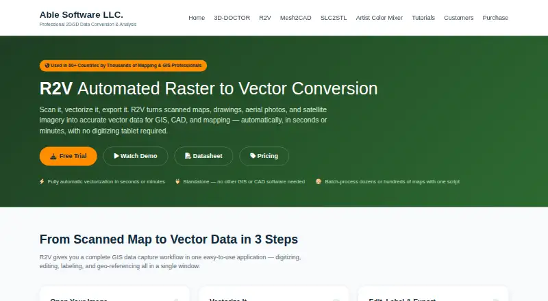
R2V is a Windows desktop application for converting scanned maps, drawings, aerial photographs, and satellite imagery into editable vector data. It is aimed at GIS, mapping, surveying, engineering, and CAD workflows, with tools for automatic raster-to-vector conversion, interactive and semi-automatic tracing, manual tracing, vector editing, labeling, OCR, georeferencing, color classification, polygon creation, and 3D terrain generation. Its output options include GIS, CAD, and 3D formats such as Shapefile, DXF, SVG, DEM, VRML, STL, and XYZ.
Pricing is one-time rather than subscription-based. The Single User plan costs $395 and includes one named user, one year of updates, and email support. The 2-User Pack costs $595 and includes two named users, one year of updates, and priority support. The Site License provides unlimited users at one site, three years of updates, and premium support. R2V also supports batch vectorization and scripting, which suits repeat conversion work, while its tracing modes cover monochrome, grayscale, and full-color images. The published plans position it for individual specialists and teams with defined site-based workflows.
R2V’s strongest distinction is its breadth across image conversion and spatial data production. Georeferencing and coordinate conversion support mapping workflows, while color classification, OCR, vector layers, and polygon creation extend the tool beyond basic tracing. Terrain professionals can also generate 3D DEM outputs and export to formats used in CAD and 3D workflows. The tradeoff is a focused desktop experience limited to Windows, with a starting cost of $395 and no free plan. Choose R2V when GIS, terrain, batch processing, or multi-format export are central requirements; teams seeking broader platform coverage or a lower-cost entry point should consider an alternative.
Your product? Our editors can test R2V in depth and publish a review, labelled as paid · from $149/mo →
R2V pricing
R2V fact sheet
| Free plan | No |
|---|---|
| Paid from | $395 one-time |
| Batch conversion | Yes |
| Tracing modes | Not verified |
| Available platforms | Desktop |
| Vector output formats | Shapefile, Arc/Info Generate, MIF/MID, DXF, IGES, SVG, MapGuide SDL, DEM, ASCII Grid, XYZ, VRML, STL |
| Batch file limit | Not verified |
| Maximum color count | 255 colors |
| Money-back guarantee | 30 days |
| Deployment | Desktop |
| Platforms | Windows |
| Support | |
| Built for | Small business, Mid-market, Enterprise (editorial estimate) |
| Pricing | Paid (source) |
| Website | ablesoftware.com |
| Facts checked | 20 Sep 2026 |
Alternatives to R2V
- VectorItA free offline vectorizer with detailed tracing controls and broad desktop export options.9.4
- EdgeSVGA developer-focused engine for automated, measurable raster-to-SVG conversion.9.3
- Adobe CaptureA free mobile vectorization tool for Creative Cloud workflows, with broad Adobe integrations.9.2



Used R2V? Be the first to review it
The editor score above is our own research. What this page doesn't have yet is a reader's view — what you used R2V for, what worked and what didn't. No stars are seeded and no review is paid for; an editor reads every one before it appears.
Write a reviewTwo minutes · verified accounts only · read by an editor before it appears
Featured on iTechGuides

R2V is listed in our Image Vectorization Software directory. Add the badge to your site — it links back to this page.
<a href="https://www.itechguides.com/products/r2v/"><img src="https://www.itechguides.com/best/badge/r2v.svg" alt="Featured on iTechGuides" width="230" height="46"></a>
Reviewed by iTechGuides Editors · Editorial team · Updated Oct 2026
Advertiser disclosure: iTechGuides is reader-supported. Vendors can pay for top positions in our rankings and for a place on other products' pages, and we may earn a commission when you click some links. Bought places stand at the number bought; this page and our disclosure say so. Paying vendors may get a fuller, more detailed review from our editors, and that review can change their score. How we rank.
Last updated · How we research and update