OpenReco
OpenReco: A broad, free photogrammetry toolkit for georeferenced 3D and GIS workflows. Ranked #25 of 34 in Photogrammetry Software by our editors (6.7/10); pricing: Free plan; best for broad, free desktop and API photogrammetry.
At a glance
- Editor score6.7 / 10
- PricingFree plan
- Best forBroad, free desktop and API photogrammetry
- Free planYes
- Paid fromFree
- DeploymentDesktop
- Facts checked20 Sep 2026
Where it wins
- Covers point clouds, meshes, orthomosaics, elevation, and measurements
- Supports Windows, macOS, Linux, and API access
- Exports to major 3D, GIS, CAD, raster, and tabular formats
Where it doesn't
- The project is described as an incomplete, early version
- Orthophoto processing is identified as approximate
- Desktop and API workflows may not suit teams seeking one hosted workspace
Our verdict on OpenReco
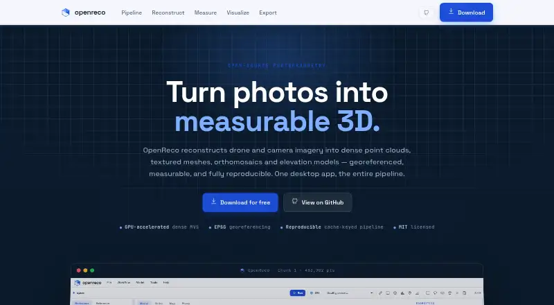
OpenReco is an open-source photogrammetry application for turning drone and camera imagery into georeferenced point clouds, textured meshes, orthomosaics, digital surface models, elevation outputs, contours, and GIS-ready files. It is aimed at surveying, mapping, agriculture, forestry, construction, heritage, robotics, and research workflows. The product combines camera alignment, sparse point-cloud generation, dense multi-view stereo reconstruction, ground-control-point support, measurements, visualization, AI features, and API access across Windows, macOS, and Linux.
Its strongest advantage is breadth. OpenReco covers the workflow from photo ingestion through reconstruction, georeferencing, measurement, and export. Users can work with EXIF GPS or ground control points, generate textured polygonal meshes, and calculate volume, area, distance, and elevation profiles. Export options include LAS, LAZ, PLY, OBJ, GeoTIFF, GeoJSON, DXF, CSV, and 3D Tiles. The reproducible cache-keyed processing pipeline also gives repeatable processing a defined place in the workflow, making OpenReco a fit for technical teams that need both 3D reconstruction and downstream GIS or CAD deliverables.
OpenReco is free and open source, so its value is concentrated in capability rather than plan-based feature separation. The published feature set is unusually wide for a free desktop tool, but the project is described as an incomplete, early version, and repository documentation identifies orthophoto processing as approximate. Its desktop-and-API deployment model will appeal to users who want local processing or programmatic access; teams looking for a polished hosted workspace or a mature, narrowly focused orthophoto workflow should consider alternatives. Choose OpenReco when format coverage, georeferencing, measurements, and reproducible processing matter more than production maturity.
Your product? Our editors can test OpenReco in depth and publish a review, labelled as paid · from $149/mo →
OpenReco pricing
OpenReco fact sheet
| Free plan | Yes |
|---|---|
| Paid from | Free |
| Deployment | Desktop |
| Orthophoto export | Yes |
| Point cloud export | Yes |
| Ground control points | Yes |
| GIS data export | Yes |
| API access | Yes |
| Free image limit | Not verified |
| Deployment | Desktop, Self-hosted |
| Platforms | Windows, macOS, Linux |
| Support | Docs |
| Built for | Solo, Small business, Mid-market (editorial estimate) |
| Pricing | Free plan |
| Website | abhibagul.github.io |
| Facts checked | 20 Sep 2026 |
Alternatives to OpenReco
- Agisoft MetashapeA capable desktop suite for geospatial modeling, mapping, and measurement workflows.9.4
- iTwin Capture ModelerA capable Windows workflow for preparing and processing infrastructure reality data locally or in the cloud.9.2
- DJI TerraA broad Windows photogrammetry suite for DJI drone and LiDAR workflows.9.0



See all OpenReco alternatives →
Used OpenReco? Be the first to review it
The editor score above is our own research. What this page doesn't have yet is a reader's view — what you used OpenReco for, what worked and what didn't. No stars are seeded and no review is paid for; an editor reads every one before it appears.
Write a reviewTwo minutes · verified accounts only · read by an editor before it appears
Featured on iTechGuides

OpenReco is listed in our Photogrammetry Software directory. Add the badge to your site — it links back to this page.
<a href="https://www.itechguides.com/products/openreco/"><img src="https://www.itechguides.com/best/badge/openreco.svg" alt="Featured on iTechGuides" width="230" height="46"></a>
Reviewed by iTechGuides Editors · Editorial team · Updated Oct 2026
Advertiser disclosure: iTechGuides is reader-supported. Vendors can pay for top positions in our rankings and for a place on other products' pages, and we may earn a commission when you click some links. Bought places stand at the number bought; this page and our disclosure say so. Paying vendors may get a fuller, more detailed review from our editors, and that review can change their score. How we rank.
Last updated · How we research and update