
OpenDroneMap
OpenDroneMap: A broad, configurable photogrammetry toolkit for local drone mapping workflows. Ranked #6 of 34 in Photogrammetry Software by our editors (8.7/10); pricing: Free plan; best for open-source drone photogrammetry users.
At a glance
- Editor score8.7 / 10
- PricingFree plan
- Best forOpen-source drone photogrammetry users
- Free planYes
- Paid fromFree
- DeploymentDesktop
- Founded2014
- Facts checked20 Sep 2026
Where it wins
- Generates orthophotos, terrain models, point clouds, and textured 3D models
- Supports GCPs, multispectral imagery, and thermal imagery workflows
- Exports GeoTIFF, LAS, LAZ, CSV, and COPC point-cloud formats
Where it doesn't
- Local processing puts project and compute management on the user
- Command-line configuration may suit technical users better than visual-first teams
- Its focus is aerial JPEG and TIFF imagery rather than general-purpose 3D capture
Our verdict on OpenDroneMap
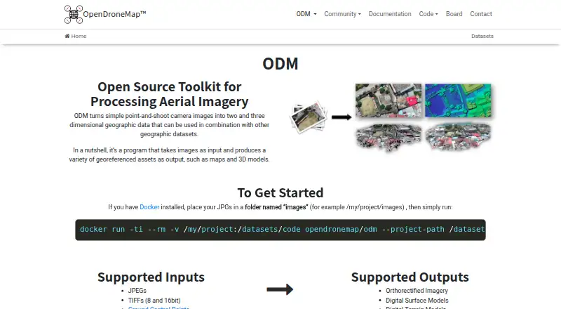
OpenDroneMap is an open-source photogrammetry toolkit for converting aerial JPEG or TIFF imagery into georeferenced geographic data. It is aimed at drone mapping, surveying, GIS, research, and other workflows that need maps or 3D spatial outputs. The desktop product supports Windows, macOS, and Linux, and its 2014 founding gives it an established place in open-source aerial mapping. Processing takes place locally through Docker or native Windows execution.
Its strongest advantage is breadth within aerial photogrammetry. OpenDroneMap can generate orthophotos with GeoTIFF export, georeferenced point clouds, digital surface and terrain models, textured 3D models, and classified point clouds. Ground control point support adds control for mapping workflows, while multispectral and thermal imagery workflows extend its use beyond standard RGB drone capture. Point-cloud export options include LAS, LAZ, CSV, and COPC, which gives GIS and spatial-data teams several ways to move outputs into downstream workflows.
The trade-off is a more technical operating model. Command-line processing and configurable reconstruction parameters provide control, but they also place more responsibility on users who need to manage inputs, local processing, and output organization. That approach fits open-source users, researchers, surveyors, and GIS practitioners who value configurable processing and broad deliverables without a software license fee. Teams seeking a primarily visual, guided workflow or a narrower, simpler mapping experience may prefer an alternative designed around less technical operation.
Your product? Our editors can test OpenDroneMap in depth and publish a review, labelled as paid · from $149/mo →
OpenDroneMap pricing
OpenDroneMap fact sheet
| Free plan | Yes |
|---|---|
| Paid from | Free |
| Deployment | Desktop |
| Orthophoto export | Yes |
| Point cloud export | Yes |
| Ground control points | Yes |
| GIS data export | Yes |
| API access | Yes |
| Free image limit | Not verified |
| Deployment | Desktop, Self-hosted |
| Platforms | Windows, macOS, Linux |
| Support | Community, Docs |
| Built for | Solo, Small business, Mid-market, Enterprise (editorial estimate) |
| Pricing | Free plan (source) |
| Website | opendronemap.org |
| Facts checked | 20 Sep 2026 |
Alternatives to OpenDroneMap
- Agisoft MetashapeA capable desktop suite for geospatial modeling, mapping, and measurement workflows.9.4
- iTwin Capture ModelerA capable Windows workflow for preparing and processing infrastructure reality data locally or in the cloud.9.2
- DJI TerraA broad Windows photogrammetry suite for DJI drone and LiDAR workflows.9.0



See all OpenDroneMap alternatives →
OpenDroneMap vs the competition
- OpenDroneMap vs Agisoft Metashape
- OpenDroneMap vs iTwin Capture Modeler
- OpenDroneMap vs DJI Terra
- OpenDroneMap vs Trimble Inpho
- OpenDroneMap vs ContextCapture
- OpenDroneMap vs WebODM



Compare OpenDroneMap with any tool side by side →
Also Ranked In
OpenDroneMap is ranked in 3 of our directories.
Used OpenDroneMap? Be the first to review it
The editor score above is our own research. What this page doesn't have yet is a reader's view — what you used OpenDroneMap for, what worked and what didn't. No stars are seeded and no review is paid for; an editor reads every one before it appears.
Write a reviewTwo minutes · verified accounts only · read by an editor before it appears
Featured on iTechGuides

OpenDroneMap is listed in our Photogrammetry Software directory. Add the badge to your site — it links back to this page.
<a href="https://www.itechguides.com/products/opendronemap/"><img src="https://www.itechguides.com/best/badge/opendronemap.svg" alt="Featured on iTechGuides" width="230" height="46"></a>
Reviewed by iTechGuides Editors · Editorial team · Updated Oct 2026
Advertiser disclosure: iTechGuides is reader-supported. Vendors can pay for top positions in our rankings and for a place on other products' pages, and we may earn a commission when you click some links. Bought places stand at the number bought; this page and our disclosure say so. Paying vendors may get a fuller, more detailed review from our editors, and that review can change their score. How we rank.
Last updated · How we research and update