
What’s actually slowing this PC down?
Pick the symptom - the matching free tool is one click away.
iTechGuides is reader-supported. When you buy through links on our site, we may earn an affiliate commission. As an Amazon Associate I earn from qualifying purchases. Learn more
Satellite measurements suggest that Masaya Volcano in Nicaragua may have two active magma-storage zones: a deeper source beneath its caldera and a much shallower source beneath Santiago crater. The study inferred these reservoirs from patterns of ground movement; it did not directly image magma underground, and it does not predict an imminent eruption.
What did researchers find beneath Masaya?
A study published in Geophysical Research Letters on July 23, 2026, used satellite radar measurements to model two distinct sources of ground deformation at Masaya. The authors call the deeper source the Masaya Central Reservoir (MCR). Their preferred model places it beneath the caldera at about 3.2 kilometers deep. A second, shallower source lies beneath Santiago crater at about 200 meters deep.
These are inferred reservoirs, not chambers that satellites photographed or researchers directly observed. The model links measured changes at the surface to likely changes in underground sources. The deeper MCR is better characterized; the shallower Santiago source is inferred from localized, persistent deflation.
Outdated Drivers Are Slowing You Down
One free scan finds every outdated or missing driver and matches the right update for your exact hardware.Free scan · exact hardware matchWindows Errors? Fix Them Before They Spread
Repair common Windows errors and clear accumulated junk for a smoother, more stable PC - no reinstall needed.Free scan · no reinstall| Inferred source | Approximate location and depth | Surface-deformation pattern in the study | Interpretation |
|---|---|---|---|
| Masaya Central Reservoir (MCR) | Beneath the caldera, about 3.2 km deep | About 3 cm of line-of-sight displacement away from the satellite from 2018 to mid-2022; the broader signal then shifted toward the satellite through February 2024 | Deflation followed by likely renewed inflation |
| Santiago crater-area source | Beneath Santiago crater, about 200 m deep | Continued localized deflation over the study window | A second, shallower modeled source that continued to lose volume |
The depths and interpretations come from the authors’ geodetic model, not a direct measurement of magma. The roughly 3 cm figure is specifically line-of-sight displacement, the component of ground movement measured along the satellite’s viewing direction; it is not a claim that the ground moved vertically by 3 cm. Read the study in Geophysical Research Letters.
#1 Best Overall
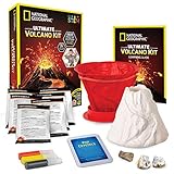
- MORE ERUPTIONS EQUALS MORE FUN – This kids science kit packs more eruption powder than ever before! You get 3x the eruption powder, plus pop crystals which add an exciting sound to your eruptions. Science kits like this are fun for everyone!
- UNFORGETTABLE SCIENCE EXPERIMENTS – This is a great hands-on experiment kit for any science fair; the updated mold and instructions make it easy to assemble a sturdy volcano form and realistic paint colors give the volcano a lifelike look.
- YOU GET REAL VOLCANIC ROCKS – Includes a pumice and a geode specimen so your kids can see real rocks created by a volcano! A full-color learning guide teaches about each rock and provides a wealth of educational information on volcano science.
- HOME SCHOOL CLASSIC – This is a classic STEM project that teaches kids about chemistry, geology, and earth science. Plus, the volcano mold is reusable, and the learning guide provides tips on different eruptions to try with common household items!
- AWARD-WINNING PRODUCTS - Blue Marble, winner of the Toy Association's prestigious Toy of the Year Award, proudly develops products that foster education, imagination, and creativity, with a U.S. support team to ensure a stellar experience!
How did satellites detect the possible reservoirs?
The researchers analyzed Sentinel-1 Interferometric Synthetic Aperture Radar (InSAR) time series. InSAR compares radar observations taken at different times to estimate how the ground surface has shifted along the satellite’s line of sight. Scientists then use geodetic models to test what underground sources could plausibly produce the observed deformation.
The study’s main analysis covers January 2018 through February 2024. It found different deformation patterns near the central caldera and Santiago crater, which the authors interpreted as evidence for two sources rather than a single source behaving uniformly. InSAR measures surface displacement; it does not detect magma directly, and the inferred depth and behavior depend on the model used to explain those measurements.
Rank #2

- STEM ENGAGEMENT - Encourages kids ages 6-10 to explore earth science through hands-on volcano experiments that simulate eruptions using safe household ingredients.
- REALISTIC DESIGN - Giant 11" cross-section model reveals internal volcano structures like magma chambers and vents, helping kids visualize geology in a fun, tactile way.
- EASY CLEANUP - Built-in spill tray and removable lava tube make post-eruption cleanup simple, allowing kids to repeat experiments without mess or frustration.
- READY TO USE - No assembly required; kids and teachers can dive into learning right away with a fully built model and included guide for structured activities.
- CLASSROOM FRIENDLY - Ideal for science centers, homeschool, or therapy settings; supports lesson planning with a detailed activity guide and reusable components.
What changed around 2022?
From 2018 to mid-2022, the central-caldera signal showed about 3 cm of movement away from the satellite along its line of sight. The authors interpret this as continued deflation of the deeper MCR. From mid-2022 through February 2024, the broader MCR signal shifted toward the satellite, which they interpret as likely renewed inflation and magma supply from depth.
The Santiago crater area kept deflating throughout the study window, including after the deeper source’s signal changed. That contrast is central to the two-reservoir interpretation: the modeled deeper source shifted from deflation toward inflation, while the shallow crater-area source continued to deflate.
Rank #3
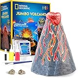
- OUR BIGGEST VOLCANO EVER - This jumbo volcano kit is our biggest yet at nearly 2 feet tall! Astound friends, family, and classmates with the stunning size and exciting eruption experiments! It's the perfect hands-on experiment for any science fair.
- EASY SETUP - Kid-friendly instructions make this jumbo volcano easy to make and erupt. Layer the plaster wrap over the frame, add plaster, and once it's dry, paint it and erupt it again and again!
- MORE ERUPTIONS, MORE FUN – This kids science kit comes with 3 packets of eruption powder plus pop crystals that add exciting crackling sounds. Instructions for more eruptions from household materials are also included.
- EVERYTHING KIDS NEED - Our jumbo volcano kit has everything kids need for an amazing science project, including the volcano mold, plaster mix and tint, two paint colors, paintbrush, and more. Genuine geode and pumice specimens are also included!
- AWARD-WINNING PRODUCTS - Blue Marble, winner of the Toy Association's prestigious Toy of the Year Award, proudly develops products that foster education, imagination, and creativity, with a U.S. support team to ensure a stellar experience!
The paper’s discussion refers to a time-series extension through April 2026, but the core analysis window reported for the study is January 2018 to February 2024. The 2022 shift should therefore be understood as a feature of the analyzed deformation record, not as a real-time statement about Masaya’s present condition.
Does a second reservoir mean Masaya is about to erupt?
No. The study presents a more detailed model of magma storage and deformation, not a forecast that an eruption is imminent. Ground inflation can be consistent with magma entering or pressurizing a source, and deflation can be consistent with magma draining away, but those are interpretations of deformation—not direct readings of magma movement or a stand-alone eruption prediction. Gizmodo’s report on the study says the researchers found no imminent threat in the result.
Rank #4

- Build and decorate a giant volcano model from cardboard and plaster and then make it safely erupt!
- Choose between two volcano shapes; both stand at 1-foot tall!
- Decorate with paint, trees, and cardboard dinos.
- Use safe, non-hazardous chemicals and dyes to create a chemical reaction of flowing red ooze, simulating molten hot lava; includes enough chemicals for multiple eruptions.
- Includes full-color volcano poster, instructions, and information sheet that explores real-life volcanoes and what causes them.
The finding also does not explain why Masaya shifts between effusive activity, such as lava flows, and explosive eruptions. The authors say longer-term geodetic observations and modeling are needed to better understand those transitions and improve hazard monitoring.
Quick wins for a faster PC:
Scan for outdated or missing drivers - takes under a minuteDriver Scan →Clear out junk files and repair common Windows errorsFree Scan →Why does monitoring Masaya matter?
Masaya is a basaltic shield volcano and complex caldera system with an active vent at Santiago crater. The 2026 study reports that about 2 million people live within 20 kilometers of the volcano. That is a proximity estimate, not a statement that everyone in that area has the same level of exposure.
Best Value
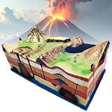
- 【Volcano Distribution Model】: Volcano demonstration model is mainly used in the teaching of geography in demonstrate the of volcano comprehensivestructures, volcano comprehensive phenomenon distributed over a wide range of space and the dynamic process of its surfaces morphology can be summarized.
- 【High Simulation】: Incorporating 3D plate tectonics, this geological model showcases a detailed representation of volcanic features and terrains,With dimensions measuring 60cm in length, 31cm in width, and 23cm in height, this comprehensive demonstration model offers a visually captivating experience.
- 【High-quality Material】: Our volcano distribution model is crafted with polymer PVC material, ensuring high density and strength,This premium material guarantees a lightweight, sturdy, and deformation-resistant construction, providing you with a long-lasting product.
- 【Educational Demonstration Model】: Designed specifically for geographical education,the volcano demonstration model offers a comprehensive understanding of the structure, phenomena, and dynamic processes of volcanoes,It serves as an invaluable tool for both students and educators alike in grasping the complexities of these geological formations.
- 【Ideal Teaching Aid】: Tailored for use in junior schools, our Volcanic Model serves as an intuitive teaching aid, facilitating the exploration of geographical education concepts,this versatile model adds depth and visual appeal to any setting, making it an excellent choice for enthusiasts and professionals alike.
The paper also describes persistent degassing and a history of large explosive eruptions; it notes that the last major lava flow was in 1772. Persistent sulfur dioxide is a known hazard, but it is distinct from the newly modeled deformation pattern and should not be mistaken for evidence that this study identified an immediate eruption threat. The authors present improved understanding of the volcano’s plumbing as a potential aid to future monitoring, not a substitute for official hazard information.
Quick Recap
Product prices and availability are accurate as of the date/time indicated and are subject to change. Any price and availability information displayed on Amazon at the time of purchase will apply.

