
What’s actually slowing this PC down?
Pick the symptom - the matching free tool is one click away.
iTechGuides is reader-supported. When you buy through links on our site, we may earn an affiliate commission. As an Amazon Associate I earn from qualifying purchases. Learn more
Lake sediments can preserve thousands of years of environmental evidence in layers. By dating a sediment core and analyzing pollen, microfossils, geochemistry, and other indicators, researchers reconstruct changes in vegetation, erosion, lake conditions, climate, and human activity. These are proxy records: evidence used to infer past conditions, not direct measurements of every variable.
How a lake becomes an environmental archive
Particles and organic material settle to a lake bed over time, building layers that can preserve clues about the surrounding landscape and the lake itself. The National Park Service describes these deposits as archives that can provide context for long-term climate and ecological variability as well as short-term observations: New Approaches to Study Interactions Among Climate, Environment, and Humans in Arctic Alaska.
To study that archive, researchers recover a core—a cylinder of sediment—and establish how its age changes with depth. They then analyze indicators, or proxies, preserved in different layers. Each proxy responds to particular processes, so interpretation depends on the lake’s setting and on how its sediments formed.
Do these 3 things before closing this tab:
1Fix the driver behind crashes, sound loss and screen glitches2Repair Windows errors before they cause bigger problems3Scan for outdated or missing drivers - takes under a minuteWhat different proxies can reveal
- Pollen can indicate which plants grew in the surrounding landscape, helping researchers infer woodland cover and composition as well as changes associated with cultivation or clearance.
- Geochemistry can provide evidence about erosion and material entering or changing within a lake. Its signal may not track human activity in exactly the same way as pollen.
- Microfossils, including diatoms, can help reconstruct past lake conditions and environmental change.
- Magnetic compounds, grain size, selected elements, trace metals, stable isotopes, and biomarkers offer additional evidence about sediment sources and environmental conditions. Which are useful depends on the site and research question.
The U.S. Geological Survey describes paleoclimate research that uses microfossils, trace-metal and stable-isotope geochemistry, and biomarkers. In its lake and marine research, temporal resolution ranges from sub-millennial to decadal, rather than following one fixed standard: USGS paleoclimate research.
#1 Best Overall

- 1.【Steel Build】304 Stainless Steel Grab Sampler combines a rigid 3L collection body with reinforced hinge points for repeated field handling. The metal construction suits wet sampling work, while the open-frame layout makes the mechanism easy to inspect after retrieval. Rinse and dry the sampler after use to help keep the bucket, hinge and rope connection ready for the next sampling task.
- 2.【Grab Sampling】Sediment Sampler uses a mechanical grab action to collect mud, silt and bottom deposits from rivers, lakes, ponds and reservoirs. Lower the open bucket with the rope, allow the jaws to reach the bed, then lift to close around the sample. The 3L grab design supports practical field collection for environmental monitoring, research work and routine sediment checks.
- 3.【20m Reach】20m Rope Sampling Kit supports manual deployment from accessible banks, docks, platforms and boats without electrical power or batteries. The 65.6 ft rope provides reach for deeper collection points, while the included work gloves assist with handling during lowering and retrieval. The rope-operated setup keeps field deployment simple for mobile sediment sampling work.
- 4.【Drainage Design】Drainage Holes allow water to pass through the grab body during lowering and retrieval, helping reduce excess water carried with the collected material. The openings also let water drain as the bucket is raised, leaving mud, silt and sediment more concentrated inside the jaws. This layout supports practical bottom sampling in a range of freshwater field environments.
- 5.【Field Uses】Bottom Sediment Sampler is designed for collecting mud, silt and sludge from rivers, lakes, ponds and reservoirs. The 3L grab bucket, 20m rope and work gloves form a ready-to-use kit for environmental monitoring, research sampling and water-related field studies. Its manual format suits users who need portable equipment for recurring bottom-deposit collection.
Why a 7,000-year record is specific to its lake
More than one study has reported a record spanning about 7,000 years. Their findings are not interchangeable: each reflects its location, basin, proxies, chronology, and the processes that affected that particular lake.
County Sligo, western Ireland
Michael O’Connell, Beatrice Ghilardi, and Liam Morrison paired geochemical and pollen records to reconstruct local erosion, woodland cover and composition, and prehistoric farming impacts. The authors interpret a woodland perturbation as the local expression of the 8.2 ka climate anomaly. Their study reports an early Neolithic farming impact in both datasets from 3715–3440 BC. That interval is a site-specific interpretation, not a general date for the beginning of farming across Europe. O’Connell, Ghilardi, and Morrison’s County Sligo study.
Rank #2
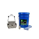
- Flapped top design reduces sample disturbance
- Constructed of stainless steel
- Environmentally friendly non-toxic steel
The authors also report increased Bronze Age farming and clearance in the pollen record, less clearly in the geochemical record. They suggest changes within the lake may help explain the difference. This divergence illustrates why researchers compare independent proxies rather than treating one signal as a complete account of the past.
Quick wins for a faster PC:
Scan for outdated or missing drivers - takes under a minuteDriver Scan →Clear out junk files and repair common Windows errorsFree Scan →Unterer Landschitzsee, Austrian Alps
A study of this Alpine lake analyzed a 3.45 m core spanning 7,000 years. Its evidence included diatoms, pollen, magnetic compounds, grain size, and selected elements. The authors describe negative climate oscillations against a longer-term humidity trend, with some fluctuations related to known Alpine climate oscillations and glacier advances. Those conclusions apply to this lake and its evidence, not to every 7,000-year sediment record. Unterer Landschitzsee study.
Rank #3

- PROFESSIONAL DESIGN: Stainless steel frame construction ensures durability and reliable performance in aquatic sampling applications
- SAMPLING EFFICIENCY: Precisely engineered net system allows for accurate collection of stream bottom organisms and sediment samples
- PORTABLE SOLUTION: Hinged frame design enables easy folding for transport and storage while maintaining structural integrity
- COLLECTION FEATURES: Includes attached collection net and frame assembly for comprehensive stream bottom sampling
- SCIENTIFIC APPLICATION: Ideal for water quality assessment, ecological surveys, and professional aquatic research projects
How researchers date sediment layers
Age must be established before a change at a particular depth can be assigned to a period in the past. Researchers select dating approaches according to the sediment and its age; the National Park Service describes piston coring and age-depth analysis and gives these examples:
- Lead-210: used for recent deposits, roughly those from the last two centuries.
- Radiocarbon dating: applied to organic matter in deposits up to about 45,000 years old.
- Paleomagnetism, thermoluminescence, or dated tephra: possible methods for older deposits.
These are method examples, not a universal sequence. A chronology may draw on more than one source of age information, and dating methods can disagree. For instance, a U.S. Geological Survey publication reports that varve dates in Elk Lake differ from radiocarbon ages, probably because old carbon was incorporated into the sediment: Elk Lake varve chronology publication.
Rank #4

- User-Friendly Design: The Mud Sampler features a grapple connected by a durable nylon rope, enabling effortless mud sampling with a simple pull-and-release action for easy operation.
- Metal Construction: Crafted from high-quality 304 Stainless Steel, our Sludge Sample Extractor is built to withstand the test of time. Its polished surface ensures easy cleaning and maintenance.
- Optimized Drainage: This sampler includes multiple drainage holes for efficient excess water removal and trapped gas release, enhancing mud capture and maximizing sludge collection.
- Convenient Sampling Mechanism: The nylon drawstring connection facilitates a quick pull-and-release action, streamlining the sampling process for user efficiency.
- Service: If you experience any issues with this product, please contact us promptly. We guarantee a response within 24 hours, ensuring your peace of mind.
When a sediment record has annual resolution
Some lakes form annual layers, called varves. Where those layers are present and validated, counting them can provide an annual chronology. The U.S. Geological Survey reports a 10,400-year varve timeseries for Elk Lake, while also noting the difference between varve and radiocarbon dates. That record is an example, not evidence that all lakes preserve countable annual layers.
Free tools Windows power users keep installed
One-click scans. No signup required.
Nor does a record lasting 7,000 years automatically resolve every year. The time detail researchers can distinguish depends on the site, proxy, how densely the core was sampled, and the reliability of its chronology. The VARDA project emphasizes quantifying age uncertainty in records: VARDA project.
Best Value

- 4-TEST DIESEL FUEL ANALYSIS – Submit a diesel fuel sample for laboratory analysis covering four key contamination concerns: water, basic sediment & water (BS&W), microbial contamination and DEF contamination.
- IDENTIFY COMMON FUEL CONTAMINATION – this 4-Point laboratory testing can help identify water, sediment, microbial activity and DEF contamination in diesel fuel when investigating suspected fuel problems or questionable fuel condition.
- COMPLETE SAMPLE COLLECTION KIT – Includes the materials needed to collect and prepare your diesel fuel sample for laboratory submission, including sample bottle, identification materials, gloves, absorbent material and protective packaging.
- LABORATORY TESTING & RETURN POSTAGE INCLUDED – The Essential Package includes the designated four-test laboratory analysis and prepaid return postage, simplifying the process from diesel fuel sample collection through laboratory submission.
- FOR DIESEL VEHICLES & EQUIPMENT – Suitable for diesel pickup trucks, commercial and fleet vehicles, generators, agricultural equipment, construction equipment, fuel tanks and other diesel-powered applications.
How to interpret claims from a sediment record
A sound reading keeps the evidence and the inference distinct. A pollen shift, for example, is evidence about plant material represented in the sediment; interpreting it as woodland clearance or farming impact requires context and comparison with other evidence. Geochemical or microfossil signals may reflect different processes, so agreement among proxies can strengthen an interpretation while disagreement can reveal limits or lake-specific effects.
Quick Recap
- Identify the lake and the study before applying a finding elsewhere.
- Check which proxies were analyzed and what each can support.
- Look for how the core was dated and whether the authors report age uncertainty or disagreement among dating methods.
- Distinguish the length of a record from its temporal resolution.
- Treat climate or human-activity conclusions as interpretations supported by evidence, not direct readings of every past condition.
Product prices and availability are accurate as of the date/time indicated and are subject to change. Any price and availability information displayed on Amazon at the time of purchase will apply.

