
iTechGuides is reader-supported. When you buy through links on our site, we may earn an affiliate commission. As an Amazon Associate I earn from qualifying purchases. Learn more
Flood exposure is increasing in studied Himalayan catchments, while government assessments describe settlements and urban growth in flood-prone parts of Nepal. A 2026 study found more building area near river channels and inside modeled glacial lake outburst flood zones between 2016 and 2023. Those findings show changing exposure in particular study areas—not that all Nepal is building in risk zones, or that construction alone caused the increase.
What the evidence says about rising exposure
A 2026 study published in Scientific Reports examined high-mountain catchments in Nepal and transboundary parts of India and China. It measured building footprints against two different hazard-related indicators. In the study area, building area within 0–50 metres of height above nearest drainage (HAND) increased 46% from 2016 to 2023. Building area inside the study’s modeled glacial lake outburst flood (GLOF) extents increased 77% over the same period.
These are exposure measures: they indicate that more mapped building area is in places associated with potential flooding. HAND is a measure of vertical elevation relative to the nearest drainage, not a simple horizontal distance from a river and not a forecast that a building will flood. A modeled GLOF extent represents a potential inundation area, not a record of a flood that occurred.
Recommended Free Tools
The study also estimates that 18% of the study-area catchment population—293,800 people—lived within 0–50 metres HAND in 2026. This is a modeled population exposure estimate, not a count of people certain to be flooded. The study’s geography and methods matter: these figures are not a uniform estimate for Nepal as a whole.
#1 Best Overall

- 72-HOUR EMERGENCY KIT FOR 2: Built for disaster preparedness at home, work or on the road, this 2-person survival backpack includes food, water, first aid, lighting, hygiene and shelter essentials for up to 3 days.
- FOOD, WATER & PURIFICATION: Includes two 2,400-calorie emergency food bars, six 4.225 oz water pouches, water purification tablets and a 32 oz BPA-free bottle to help support hydration and nutrition during outages or evacuations.
- FIRST AID & PERSONAL PROTECTION: Packed with a 33-piece first aid kit, 2 N95 dust masks, nitrile gloves, hygiene kits, ponchos, survival blankets and tissues for added protection, sanitation and comfort during emergencies.
- POWER, LIGHTING & COMMUNICATION: Includes a hand-crank emergency power station with flashlight, AM/FM radio, siren and cell phone charging, plus 2 emergency lightsticks and a 3-in-1 whistle, compass and thermometer.
- DELUXE SURVIVAL TOOLS IN ONE BACKPACK: Adds a multi-function tool, duct tape, bio-hazard bag and emergency contact card in a portable backpack. Ideal for earthquakes, hurricanes, blackouts, wildfire evacuation, cars and workplaces.
How the national and Terai figures differ
Separate government assessments describe flood exposure at different scales and with different definitions. Their figures provide context, but should not be combined with the 2026 catchment measurements as if they were one consistent national time series.
| Source and geography | Measure | What the figure means |
|---|---|---|
| Nepal Ministry of Forests and Environment, 2021 rural and urban settlement assessment | About 8% of Nepal | Area the assessment classifies as flood-prone; the figure depends on that report’s definitions. |
| Nepal Ministry of Forests and Environment, 2021 assessment | 3,443 flood events during 1971–2019 | Events recorded over the report’s specified period, not a current annual rate. |
| Department of Water Resources and Irrigation; six prioritized Terai basins | 29,356 hectares and 70,428 people | Exposure under a 1-in-50-year flood case for those basins, not a nationwide count. The publication page does not state a date. |
The Terai basin estimate concerns river-flood exposure in six prioritized basins; it is not interchangeable with high-mountain HAND or modeled GLOF measurements. A GLOF occurs when water released from a glacial lake travels downstream, while river flooding can result from intense rainfall and other conditions. Nepal Disaster Report 2024 identifies GLOFs as a hazard for Himalayan settlements and downstream areas, but does not quantify a construction trend.
Rank #2

- 72 HOUR EMERGENCY KIT FOR 2 PEOPLE WITH FOOD AND WATER: Includes 2 emergency food bars totaling 4800 calories and 12 sealed drinking water pouches to support hydration and energy during disasters. Designed for emergency preparedness, survival kits, earthquake kits, and evacuation planning.
- COMPLETE DISASTER SURVIVAL KIT WITH SHELTER AND WARMTH: Equipped with 2 emergency ponchos and 2 survival blankets to help protect against rain, wind, and cold conditions. Critical gear for outdoor emergencies, power outages, and shelter in place situations.
- FIRST AID KIT AND SAFETY PROTECTION SUPPLIES: Features a 33 piece first aid kit, dust masks, and nitrile gloves to support basic medical care and protection from debris and airborne particles. Essential for emergency response, injury care, and disaster safety.
- EMERGENCY LIGHTING AND SIGNALING TOOLS INCLUDED: Comes with 2 long lasting 12 hour lightsticks and a safety whistle for visibility and communication in low light or rescue situations. Ideal for blackout emergencies, nighttime evacuation, and search scenarios.
- COMPACT BACKPACK FOR GRAB AND GO EVACUATION: Lightweight emergency backpack keeps all survival supplies organized and ready for fast response. Perfect for home emergency kits, car emergency kits, office preparedness, and bug out bags.
Why settlements remain exposed
Nepal’s 2021 Ministry of Forests and Environment assessment describes informal settlements in rapidly growing cities on exposed riverbank land. It notes: “Many such settlements are located on land exposed to extreme weather such as river banks that are prone to flash floods.” The assessment also says intense rainfall can increase flood losses, particularly in flood-prone Terai areas, where impermeable urban surfaces can increase runoff.
Quick wins for a faster PC:
Scan for outdated or missing drivers - takes under a minuteDriver Scan →Repair Windows errors before they cause bigger problemsFix Now →Fix the driver behind crashes, sound loss and screen glitchesFind Drivers →A separate sector report attributes an increasing flood trend mainly to climate change and land-use change, and identifies urban concerns including impervious surfaces, runoff and drainage capacity. Together, these accounts point to interacting influences: where development takes place, how much rain falls, how water drains, and what flood protection or warning systems are available. The sources do not assign a single share of the trend to climate change or construction.
Rank #3

- Prepare Now for the El Nino Storm Season: El Nino pushes storms closer to the U.S. coast, leaving as little as 48 hours to prepare. Backup supplies when weather catches you off guard
- Hand-Assembled in New England: Designed by a disaster professional and assembled by a real person, not a faceless factory. Every kit checked by hand before it ships
- Emergency Lifeline When You're Stuck: For flash floods, closed roads, or power outages when you can't reach a store. Below-average hurricane forecast for El Niño doesn't mean no risk-the storm that hits may arrive faster and closer to home
- Upgraded 2026 Version: Premium lined and insulated rain poncho replaces economy version plus expanded comfort kit for extended emergencies
- Comfort-Focused Emergency Kit: Beyond basic first aid with bandages, bacitracin, lip balm, alcohol wipes, PLUS hand lotion and dental pick
The 2026 study mentions informal settlement expansion and tourism-driven construction along some river corridors. That is a site-specific observation from its study area, not proof of a nationwide development pattern. The evidence supports concern about growth in exposed locations, but not the claim that new construction is increasing in every vulnerable part of Nepal.
Exposure is not the same as vulnerability or damage
Exposure means people, buildings or other assets are located where a hazard could reach them. Vulnerability is about how susceptible they are and their capacity to withstand, respond to and recover from an event. Income, housing security or tenure, and access to social and human resources can all affect vulnerability.
Rank #4

- ESSENTIAL EVACUATION SUPPLIES: Designed to help people escape a building and get through the first hours of an emergency.
- FOOD AND WATER: Includes one 400-calorie food bar and one 4.225-ounce water pouch; both have a five-year shelf life.
- EMERGENCY GEAR: Includes a 12-hour emergency lightstick, emergency whistle, dust mask, two nitrile gloves, survival blanket, pocket tissue pack, and safety goggles.
- ONE-PERSON KIT: Provide one for every person in a facility.
- FIVE-YEAR SHELF LIFE.
More mapped building area in a hazard-related zone does not by itself establish how many people will be harmed, how severe losses would be, or whether a particular building is unsafe. Those outcomes also depend on the flood’s probability and intensity, building conditions, drainage and protection, warning time, and residents’ ability to respond. The 2026 study notes that consistent high-resolution exposure data are scarce and that building-footprint datasets vary in accuracy and completeness, so its results should be read as measured estimates rather than a complete census of risk.
The Tool Desk
Outbyte PC Repair FREERepair Windows errors before they cause bigger problemsFix Now →Outbyte Driver Updater FREEScan for outdated or missing drivers - takes under a minuteDriver Scan →What the findings imply for planning
The evidence makes safer siting and better land-use decisions central to reducing future exposure, alongside measures that manage water and prepare communities. Relevant approaches include keeping new development out of mapped flood pathways where feasible, improving urban drainage and flood protection, and strengthening early warning and community response. The available figures identify a planning problem; they do not evaluate the effectiveness of any specific intervention.
Best Value
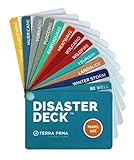
- KNOW EXACTLY WHAT TO DO — When a wildfire, earthquake, or hurricane hits, the brain freezes — even for prepared people. The Disaster Deck gives you clear, calm, step-by-step actions for 12 real disasters so you and your family move with confidence, not panic. No searching, no guessing. Just open it and go.
- 12 DISASTERS, ONE POCKET-SIZED DECK — Covers wildfire, earthquake, hurricane, flooding, tornado, tsunami, power outage, extreme heat, volcano, lightning, landslide, and emotional wellness — because staying mentally grounded is part of surviving any emergency. Color-coded guides make the right action instantly obvious, even under stress.
- READY WHEREVER LIFE TAKES YOU — Lightweight and waterproof — built for real conditions, not a bookshelf. Slips into a bug out bag, glove box, backpack, purse, or emergency kit without taking up space. Perfect for families, campers, hikers, travelers, and anyone who wants to feel genuinely prepared without being overwhelmed by it.
- EXPERT-BACKED, REAL-WORLD TESTED — Developed with emergency preparedness professionals and trauma-informed experts — not generic internet checklists. Includes proven mental wellness steps to reduce panic and help your whole family stay focused when it matters most. This is disaster resilience, not just disaster information.
- MADE IN THE USA BY A WOMEN-OWNED SMALL BUSINESS — Terra Frma is built on one belief: preparedness should feel like relief, not fear. Every guide is made in the USA with high-quality, durable materials designed to last through real emergencies — and real life. A thoughtful gift for parents, new homeowners, college students, or anyone you want to feel safe.
For residents and decision-makers, the key question is not simply whether a place is labeled “flood-prone.” It is which hazard is being considered, what map or measurement defines the exposed area, how current and reliable that information is, and what protection and response capacity exists. A river-flood map, a HAND measure and a modeled GLOF extent describe different aspects of exposure and should not be treated as equivalent.
Quick Recap
Product prices and availability are accurate as of the date/time indicated and are subject to change. Any price and availability information displayed on Amazon at the time of purchase will apply.

