
Do these 3 things before closing this tab:
1Scan for outdated or missing drivers - takes under a minute2Clear out junk files and repair common Windows errors3Fix the driver behind crashes, sound loss and screen glitchesiTechGuides is reader-supported. When you buy through links on our site, we may earn an affiliate commission. As an Amazon Associate I earn from qualifying purchases. Learn more
ESA’s image “Navigation documentary filming at ESTEC,” published on 5 October 2026, shows the Erasmus High Bay at the European Space Agency’s technical centre in Noordwijk, the Netherlands, set up for filming a documentary on European satellite navigation. The film is Finding Our Way: Inside the Galileo Project, which ESA commissioned in 2025 to document the history of Galileo. ESA scheduled its YouTube premiere for 15 October 2026 at 18:30 CEST.
What the ESA image shows
The image entry places the shoot in the Erasmus High Bay at ESTEC, the European Space Agency’s technical centre in Noordwijk. The description confirms that the space was prepared for documentary filming. It does not identify the crew, the equipment, or the exact day the filming took place, so those details should not be assumed from the picture.

What the documentary covers
Director Johannes Walden told ESA that the film follows three broad movements. Each one corresponds to a different stage of the Galileo story.
The Tool Desk
Outbyte Driver Updater FREEScan for outdated or missing drivers - takes under a minuteDriver Scan →Outbyte PC Repair FREERepair Windows errors before they cause bigger problemsFix Now →| Part | Focus, as described by the director |
|---|---|
| 1. Origins | The historical and political context in which satellite navigation, and eventually Galileo, emerged |
| 2. Building the system | The technical, political and organisational challenges of making Galileo real as an independent European navigation system |
| 3. Present and future | Where Galileo stands today and where satellite navigation is heading next |
Taken together, the structure runs from the political background, through the engineering and institutional effort, to the system’s current position. That makes the film more of a history-plus-status account than a technical explainer.
#1 Best Overall
How the production approach changed
Walden said the team began with a rigid storyboard and shooting plan and moved away from it. In his words: “I changed my mindset from a rigid storyboard and shooting plan to a more flexible and creative approach.”
Walden also said the production interviewed nearly 20 people, all of them senior figures with busy schedules. That number comes from his own account in an ESA interview published on 8 October 2026. It is his description of the production, not an independently checked count.
Rank #2

- Large Screen:Large 3.2" sunlight-readable color display with 240 x 320 display pixels for improved readability,even in bright sunlight
- Professinal Accuracy: Supports 6 satellite systems (GPS, Beidou, Galileo,GLONASS, NAVIC and QZSS ) for high presion measurement, area error < 0.002 acres,distance error < 5 ft
- 7 Measurement Modes: Supports area measurement of irregular and regular terrain such as ranches, garden; length measurement of straight and curved lines, height and slope measurement, and can also save the coordinate points of the current position (can only save coordinates, cannot be modified)
- Rugged With Long Battery Life: IP65-rated for superior durability; powered by internal 4000 mAh Li-ion rechargeable battery, up to 48 hours in continuous use
- TIPS!!!: The device needed to be held horizontal for taking measurements. Recommend to measure Area above 0.04 acres and distance above 328ft. The larger the measurement range, the smaller the error.The altitude data displayed on the device is GPS altitude, which fluctuates with changes in the satellite signals received. This is normal
Archive footage and AI-assisted imagery
According to the same ESA interview, the production drew on a substantial amount of recent ESA archive footage but had fewer images from earlier periods. The team gathered hundreds of photographs. Walden said AI tools helped enhance some of them and turn others into short clips suitable for the screen. He put it this way: “During production, the AI revolution was gaining momentum, which helped us enhance some of the photos we had or turn them into short videos to make them work for the screen.”
These are Walden’s statements about the production. ESA has not published an independent assessment of how the imagery was processed.
Rank #3

- Dimensions: The miniature model by Old Modern Handicrafts measures 9 x 19 x 11 inches, this model striking centerpiece and fits comfortably into smaller spaces.
- Premium Quality Material: Old Modern Handicrafts crafted with meticulous attention to detail using premium-grade iron, ensuring longevity and authenticity.
- Detailings: Features include sun shields, scanners, thrusters, generators, probes, antennae, and more. From sun shields to thrusters, each component replicates the original.
- Uniqueness: Standing as a true testament to human innovation and exploration, this miniature model showcases the distinctiveness of NASA's Galileo mission.
- Perfect for Gifting: Ideal for space enthusiasts, and collectors, this meticulously crafted scale model is the perfect gift choice, sure to spark wonder and fascination.
Why ESTEC: the 2025 navigation milestone
ESA’s 2025 account states that the year marked three decades of satellite navigation in Europe. On 2 September 2025, ESA opened ESTEC to partners from across the continent for a celebration that highlighted Galileo and EGNOS. The documentary’s location and its subject connect to that anniversary, though ESA’s sources do not state that the film was made as part of the celebration.
The NavLab drone: background, not part of the shoot
ESA says its Navigation Laboratory is based at ESTEC. The laboratory’s work includes a drone that carries satellite-navigation receivers to collect data for later analysis. This establishes that navigation research is carried out at the site. It does not show that the drone appears in the image or in the film.
Rank #4
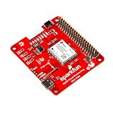
- The SparkFun ZED-F9R GPS-RTK pHAT is a high-precision Automotive Dead Reckoning board with equally impressive configuration options.
- Features: 1x Qwiic Connector, Integrated U.FL connector for use with antenna of your choice, Concurrent reception of GPS, GLONASS, Galileo and BeiDou, 184-Channel GNSS Receiver, Receives both L1C/A and L2C bands and much more!
- The ZED-F9R module is an 184-channel u-blox F9 engine GNSS receiver, meaning it can receive signals from the GPS, GLONASS, Galileo, and BeiDou constellations with ~0.01-meter accuracy! That's right, such accuracy can be achieved with an RTK navigation solution when used with a correction source.
- This pHAT maximizes position accuracy in dense cities or covered areas compared to other GPS modules. Even under poor signal conditions, continuous positioning is provided in urban environments and available during complete signal loss (e.g., short tunnels and parking garages). The ZED-F9R is the ultimate solution for autonomous robotic applications that require accurate positioning under challenging conditions.
- The SparkFun Qwiic Connect System is an ecosystem of I2C sensors, actuators, shields and cables that make prototyping faster and less prone to error. All Qwiic-enabled boards use a common 1mm pitch, 4-pin JST connector. This reduces the amount of required PCB space, and polarized connections mean you can’t hook it up wrong.
Watching the premiere
- Scheduled date: 15 October 2026, 18:30 CEST, on YouTube, according to ESA’s announcement.
- Status check: The premiere was a scheduled event at the time of writing. Confirm on ESA’s own channels that the film has gone live before sharing a viewing link.
- Time zone: 18:30 CEST is Central European Summer Time. Readers in other time zones should convert the time before the premiere starts.
The title ESA uses for the film is Finding Our Way: Inside the Galileo Project. Searching for that exact name should return the premiere once it is live.
Quick wins for a faster PC:
Clear out junk files and repair common Windows errorsFree Scan →Scan for outdated or missing drivers - takes under a minuteDriver Scan →Quick Recap
Best Value

- Compatible with , and Linux operating systems for broad software support including GIS mapping, navigation, and geotagging applications
- Features UBX-7020 chipset delivering sensitivity GPS reception and fast time-to-first-fix in urban and suburban environments
- USB-powered design enables plug-and-play without external power adapters or batteries
- Designed as a direct replacement for BU-353S4 and BU-353 S4 models with identical form factor and NMEA 0183 output protocol
- Supports simultaneous GPS and GLONASS satellite tracking for improved positional accuracy and
Product prices and availability are accurate as of the date/time indicated and are subject to change. Any price and availability information displayed on Amazon at the time of purchase will apply.

