
iTechGuides is reader-supported. When you buy through links on our site, we may earn an affiliate commission. As an Amazon Associate I earn from qualifying purchases. Learn more
Google does not state a fixed lifespan for downloaded offline maps. They do expire and need updating; the often-mentioned 15 days is the window when Google Maps tries to update an area over Wi-Fi, not a promise that every download lasts 15 days.
What the 15-day window means
Google Maps says it tries to update an offline area automatically when it is within 15 days of expiring and your device is connected to Wi-Fi. The help instructions do not say how long a map lasts before reaching that window, and an automatic update is an attempt rather than a guarantee. See Google’s Android offline maps instructions or its iPhone and iPad instructions.
How to update an offline map
-
Open Google Maps and go to the Offline maps list.
-
Select the area marked as expired or expiring.
-
Tap Update. You can also check the app’s Auto-update offline maps setting.
Do these 3 things before closing this tab:
1Repair Windows errors before they cause bigger problems2Scan for outdated or missing drivers - takes under a minute3Clear out junk files and repair common Windows errorsSpecial offer. See more information about Outbyte and uninstall instructions. Please review EULA and Privacy policy.
Labels and menu locations can vary by app version. If you are preparing for travel, check the Offline maps list while you still have an internet connection rather than relying only on automatic updating.
#1 Best Overall

- 【GPS Satellite Connection】URFRU Navigator was communication with GPS satellites directly, no needs the mobile network. and it can smart corrected the route by GPS signals to provide accurate navigation. 【Note! GPS single can not connection indoor, it should be turn on outdoor for work well.】
- 【Preloaded Maps and Free Updates】Preloaded with the latest North American offline maps (USA, Canada, Mexico), and all the URFRU GPS navigator device was able to update the maps for free lifetime.
- 【Full In-Vehicle GPS Functions】Supports zip code, address, coordinates, favorites, and POI search. Supports multiple route modes: cars, trucks, buses, taxis, bicycles, emergency vehicles, and even pedestrians.
- 【Customized Routes】Smart route planning finds the best way to your destination with accurate maps. Just enter an address, GPS coordinates, or a point of interest (like a parking lot or gas station). Choose from four route options: Fast, Green, Short, or Convenient. For trucks, routes can be customized by vehicle weight, length, height, and width to avoid restricted roads.
- 【Smart Voice Navigation】The GPS provides speed camera alerts, voice-guided route planning, road name announcements, current speed and lane guidance, plus remaining distance and estimated arrival time.
What works offline—and what does not
Offline driving is available only when the entire route falls within the downloaded map area. Google Maps does not provide traffic information or alternative routes offline. Offline directions for public transport, cycling, and walking are unavailable.
Plan the download before you travel
-
Download the area while connected to the internet, and ensure it includes your destination and the full driving route.
Rank #2
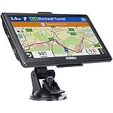 OHREX N700 GPS Navigator for Car Truck RV,Truck GPS Commercial Drivers 2026
- 【Latest 2026 North America Maps】 OHREX 7" GPS Navigator for Car Truck RV works completely offline without cell service. It comes preloaded with 2026 North America maps (USA, Canada, Mexico) and does not require an internet or cellular connection to navigate.
- 【Free Lifetime Map Updates 】 Get the latest map by connecting OHREX GPS Navigation to the Windows pc. You can also use an exteranl TF Card for map update (with Mac & Windows system). Lifetime Map is free updated without Ads . You can regularly download latest data for maps, speed, and points of interest.
- 【Driver Alerts】 OHREX N700 GPS uses satellite positioning to determine your location and provides turn-by-turn voice guidance, speed camera and real-time alerts even in areas with no cell service — perfect for remote truck and RV routes.
- 【Professional GPS Navigation】 OHREX 7 inch TouchScreen GPS Navigation for Car Truck Motorhome & RV.(1) You can Customize Route According to Your Vehicle’s Weight, Length, Height and Width, Avoid Roads with Width/Height/Weight Restrictions (2) Intelligent Route Planning Fast & Economical. (3) Fast & Accurate GPS Tracking. (4) Displays Current Speed and ETA.
- 【Professional Solution】OHREX GPS navigation supply regular maps upgrades and any question inquiry. USA local brand, established professional technician team in the United States, have been recognized by our customers.
-
Check the Offline maps list for an update before leaving. Automatic updating depends on Wi-Fi and may not complete.
Special offer. See more information about Outbyte and uninstall instructions. Please review EULA and Privacy policy. -
Check availability for your destination: offline map downloads are unavailable in some countries or regions because of contractual limitations, language support, address formats, or other reasons.
Rank #3
 Handheld GPS for Hiking, Rugged and Waterproof Handheld GPS Navigator, 3.2" Sunlight Readable Screen, Compact Satellite Handheld GPS with USA Topo Map, Multi-GNSS Support, Extra Battery Life
- Compact and lightweight GPS handheld navigator boasts an anti-slip design offering a bright 3.2" screen that is sunlight readable, even in bright sunlight, plus, physical buttons provide more versatility in any conditions
- Get multi-GNSS support(GPS+GALILEO+BEIDOU+QZSS) for superior positional accuracy,so you know exactly where you are,location precision within 6 ft
- The handheld GPS navigator uses GPS technology to capture your trip or waypoint so you can guide back to your starting position
- Equip with 3-axis compass and barometric altimeter,follow your bearing on the digital compass, which provides an accurate heading even when stationary
- Hike in any weather with the water-resistant design (rated to IP66) ,Rechargeable battery can provide up to 36 hours of battery life in full charge, recharge easily with a standard USB-C cable
Where Android stores offline maps
On a compatible Android device, Google Maps can save offline maps to an SD card configured as portable storage. Changing the storage preference requires downloading the map again, and not every device supports this option. Google’s Android instructions describe the SD-card option.
Quick Recap
Rank #4

- 【GPS Satellite Connection】URFRU Navigator was communication with GPS satellites directly, no needs the mobile network. and it can smart corrected the route by GPS signals to provide accurate navigation. 【Note! GPS single can not connection indoor, it should be turn on outdoor for work well.】
- 【Preloaded Maps and Free Updates】Preloaded with the latest North American offline maps (USA, Canada, Mexico), and all the URFRU GPS navigator device was able to update the maps for free lifetime.
- 【Full In-Vehicle GPS Functions】Supports zip code, address, coordinates, favorites, and POI search. Supports multiple route modes: cars, trucks, buses, taxis, bicycles, emergency vehicles, and even pedestrians.
- 【Customized Routes】Smart route planning finds the best way to your destination with accurate maps. Just enter an address, GPS coordinates, or a point of interest (like a parking lot or gas station). Choose from four route options: Fast, Green, Short, or Convenient. For trucks, routes can be customized by vehicle weight, length, height, and width to avoid restricted roads.
- 【Smart Voice Navigation】The GPS provides speed camera alerts, voice-guided route planning, road name announcements, current speed and lane guidance, plus remaining distance and estimated arrival time.
Product prices and availability are accurate as of the date/time indicated and are subject to change. Any price and availability information displayed on Amazon at the time of purchase will apply.

