
Free tools Windows power users keep installed
One-click scans. No signup required.
iTechGuides is reader-supported. When you buy through links on our site, we may earn an affiliate commission. As an Amazon Associate I earn from qualifying purchases. Learn more
If a drone is hovering over your property, first protect people and avoid interfering with the aircraft. Move indoors or away from the drone if it appears unstable, unusually low, close to people, or connected to a suspected crime. Call local law enforcement first for immediate danger or criminal conduct. Do not shoot at the drone, throw objects, use a laser, jam its signal, or try to capture it. If it is safe, record the time, location, duration, direction of travel, altitude estimate, markings and observable behavior. In the United States, apparent aviation-rule violations go to the local Federal Aviation Administration (FAA) Flight Standards District Office, while privacy, harassment and trespass issues depend on local law and facts.
What to do immediately
A hovering drone is not automatically proof of trespass, surveillance or another crime. Treat the situation as a safety and reporting problem until you know more.
- Move people and animals to a safer place. Go indoors or behind solid cover if the aircraft is flying close to people, appears damaged, is carrying something, or is behaving unpredictably. Keep children away from the area directly below it.
- Call local emergency services or police for an immediate threat. The FAA says to contact local law-enforcement first responders immediately when a drone operation appears dangerous or is being used to commit a crime.
- Do not touch or disable the drone. Do not shoot at it, throw objects, spray it, shine a laser, use a signal jammer, launch another aircraft, or attempt to seize it. Interference can cause a crash, injure someone and create additional legal problems.
- Observe from a safe position. Note what you can actually see rather than guessing the pilot’s intent. A drone hovering does not, by itself, show that it is recording, spying or breaking a law.
- Preserve lawful evidence. If you can do so without approaching the aircraft or trespassing, take photographs or video from your property or a public place. Keep the original files and write down when and where they were made.
Choose the right reporting channel
The correct agency depends on what is happening and where you are. In the United States, aviation-safety complaints and local-law complaints are separate tracks.
Do these 3 things before closing this tab:
1Repair Windows errors before they cause bigger problems2Scan for outdated or missing drivers - takes under a minute3Clear out junk files and repair common Windows errors| Situation | First contact | What to report | When |
|---|---|---|---|
| Immediate danger to people or property | Local law-enforcement first responders | Low or erratic flight, collision risk, crash, injury, fire or other urgent hazard | Immediately |
| Suspected crime involving the drone | Local law enforcement | Observable conduct and why you believe a crime may be occurring | Immediately |
| Apparent violation of U.S. FAA flight rules without an emergency | Your local FAA Flight Standards District Office | Time, place, aircraft behavior and any evidence of a rule violation | As soon as practical |
| Privacy, harassment or trespass concern | Local police or another authority designated by local law | Repeated targeting, suspected recording, entry onto restricted land or harassment-related facts | Promptly, according to local procedure |
| Safety incident outside the United States | The country’s aviation authority and local police | Near miss, collision risk, injury, damage and relevant evidence | Follow that country’s reporting deadlines |
The FAA’s reporting guidance, last updated December 16, 2024, says that its investigators may investigate apparent FAA-rule violations and follow up with the operator. It does not replace emergency police response.
#1 Best Overall

- REAL-TIME PRESENCE AWARENESS Track drones as soon as they enter your airspace with instant detection alerts. Know when and where an unmanned aircraft shows up — not hours later.
- DIARY LOG & HISTORICAL RECORDS The Bridge Kit logs every detection. Keep a searchable timeline of drone activity — perfect for reporting incidents to law enforcement, HOA boards, security teams, or legal documentation.
- PRECISE REMOTE ID STREAMING Supports Remote ID reception to capture both drone location and operator coordinates (when available). Connects directly to mobile apps for easy situational context.
- EASY SETUP + DAILY USE Portable and simple to deploy — just power and place. Ideal for both fixed site monitoring or traveling missions. Works with recommended companion apps for visual tracking.
- Backed by a Veteran-Owned U.S. Company: Trusted by teams across the country looking for affordable, effective counter-drone solutions without the complexity.
What U.S. FAA rules can—and cannot—tell you
The FAA’s January 14, 2025 explainer says drone pilots must operate so the aircraft does not pose a hazard to people or property. It summarizes general recreational-flying requirements that include staying below 400 feet, keeping the drone within visual line of sight and avoiding other aircraft and hazardous operations. These are general rules, not a determination that a particular flight over your property is unlawful.
The same FAA guidance makes an important boundary clear: “The FAA does not regulate privacy, but local privacy laws may apply to drone operations.” Whether a flight violates privacy, harassment, voyeurism, photography, imaging or trespass rules therefore depends on the state, city, country and specific facts. The FAA can address aviation safety and compliance with federal flight rules; it does not decide every dispute about what a camera may have captured.
A drone’s presence over private land also does not automatically mean the operator committed trespass. Airspace rights, property boundaries and remedies are governed by a mix of federal aviation authority and local law. Avoid relying on broad claims such as “I own all the air above my house” or “any drone over my yard is illegal.” Those statements are not a substitute for a jurisdiction-specific legal assessment.
What’s actually slowing this PC down?
Pick the symptom - the matching free tool is one click away.
What not to do
Do not shoot at the aircraft
FAA guidance states that shooting at any aircraft, including an unmanned aircraft, is illegal under federal law. A projectile can strike the drone, another aircraft or a person on the ground. A falling battery or propeller-equipped aircraft can also cause injury or property damage. Even if you believe the drone is invading your privacy, use reporting and legal channels instead of a weapon.
Do not jam, hack or take control
Signal jammers and attempts to commandeer a drone can disrupt communications, interfere with other equipment and make the aircraft crash. The same warning applies to lasers, nets, water, thrown objects and launching your own drone to chase it. These actions increase risk and may violate federal, state or local law.
Do not confront a suspected operator aggressively
If you see someone holding a controller, keep your distance and avoid escalating the encounter. Tell police what you observed, where the person was standing and what the drone did. Do not enter another person’s land to identify or follow the operator.
Rank #2
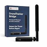
- REAL-TIME PRESENCE AWARENESS Track drones as soon as they enter your airspace with instant detection alerts. Know when and where an unmanned aircraft shows up — not hours later.
- DIARY LOG & HISTORICAL RECORDS The Bridge Kit logs every detection. Keep a searchable timeline of drone activity — perfect for reporting incidents to law enforcement, HOA boards, security teams, or legal documentation.
- PRECISE REMOTE ID STREAMING Supports Remote ID reception to capture both drone location and operator coordinates (when available). Connects directly to mobile apps for easy situational context.
- EASY SETUP + DAILY USE Portable and simple to deploy — just power and place. Ideal for both fixed site monitoring or traveling missions. Works with recommended companion apps for visual tracking.
- Backed by a Veteran-Owned U.S. Company: Trusted by teams across the country looking for affordable, effective counter-drone solutions without the complexity.
Do not publish accusations as facts
Describe observable details—“the drone hovered over the rear garden for approximately eight minutes”—rather than unsupported conclusions such as “the pilot recorded my family.” Evidence may later show recording, but hovering alone does not establish it.
How to document the incident safely
Good notes help emergency dispatchers, police, aviation investigators and a lawyer understand the event. Make the record while details are fresh.
- Date and exact time: Record when the drone appeared, when it left and any separate visits.
- Location: Note your address, the part of the property involved and whether you were indoors, in a yard or in a public area.
- Duration and path: Estimate how long it hovered, where it came from, the direction it traveled and whether it returned.
- Height and distance: Give a cautious estimate, such as “above the roofline” or “approximately tree height,” rather than claiming a precise altitude you could not measure.
- Appearance: Record color, size, number of arms or propellers, lights, visible camera, sound, markings and any payload. Do not approach it to read a serial number.
- Behavior: Describe circling, following, rapid descent, lights directed toward windows, contact with structures, near misses or other concrete actions.
- People and vehicles: Note any visible operator, controller, vehicle, license plate only if lawfully observable, and the direction in which they left.
- Evidence handling: Keep original photographs and videos, preserve their timestamps, and make a backup. Do not edit the only copy or add captions that could obscure the original context.
- Witnesses: Ask willing witnesses to write their own observations and contact details. Do not coach them or pressure them to adopt your interpretation.
When you call, explain the immediate risk first. Dispatchers need to know whether anyone is in danger, whether the drone has crashed and whether the operator may be committing another offense. For a non-emergency FAA complaint, provide the same factual log and identify any safety rule you believe may be implicated without claiming certainty.
Handling privacy, harassment and suspected recording
Privacy concerns often involve more than the aircraft’s position. Relevant facts may include repeated targeted flights, prolonged hovering outside a bedroom or bathroom window, images of a person in a private setting, threats, stalking-like conduct or an operator returning after being warned. The legal test and available remedy differ by jurisdiction.
Start with local police when you suspect harassment, voyeurism, stalking or another crime. Ask which agency handles a civil privacy or property dispute if police do not treat the matter as criminal. For repeated incidents, a qualified lawyer in your state or country can explain applicable privacy, nuisance, trespass and evidence rules. Do not assume that a police decision not to make an arrest resolves every civil question.
Crashes, No Sound, or Screen Glitches?
Random freezes, missing sound and display glitches usually trace back to one bad driver. Find and replace yours safely.Free scan · under a minuteWindows Errors? Fix Them Before They Spread
Repair common Windows errors and clear accumulated junk for a smoother, more stable PC - no reinstall needed.Free scan · no reinstallThe FAA’s aeronautical information recognizes that state and local laws may address privacy, harassment, trespass, voyeurism, photography and imaging, subject to limits involving aviation safety and airspace use. This is why the same flight can raise an FAA question, a local-law question or neither, depending on its conduct and location.
Rank #3

- 【𝐔𝐩𝐠𝐫𝐚𝐝𝐞𝐝 𝐁𝐞𝐞𝐩𝐞𝐫 𝐅𝐞𝐚𝐭𝐮𝐫𝐞】The R111S drone remote id module includes a built-in beeper, making it easier to locate lost aircraft. This enhancement provides added convenience when retrieving your drone from challenging locations, adding another layer of safety and control to the flying experience.
- 【𝐅𝐢𝐧𝐝 𝐓𝐡𝐞 𝐋𝐨𝐬𝐭 𝐀𝐢𝐫𝐜𝐫𝐚𝐟𝐭】This remote id module for drone can be used as a GPS tracker for FPV drones, RC gliders, RC helicopters, RC jet fighters, fixed-wing aircraft, fixed-wing helicopters, multirotors, flapping-wing drones, paragliding drones, etc. By integrating the aircraft's original positioning function with the module's app, it enables precise real-time tracking within a range of 500-1000 meters for dual positioning, enhancing the safety and reliability of your flight adventures.
- 【𝐅𝐀𝐀 𝐂𝐨𝐦𝐩𝐥𝐢𝐚𝐧𝐭】Ruko R111S remote id module can ensure all drones over 250g comply with FAA regulations. It is applicable to all Ruko drones and various other brands/models such as DJI Mini 2 SE, Mini 4K, Mini 3, Mini 3 Pro, Mini 4 Pro, Air 2S, Air 3, Mavic 3, Mavic 3 Pro, Avata 2, FPV, Spark, Phantom 2, Phantom 3, Phantom 3 SE, Phantom 4, Inspire 1, Inspire 2, Inspire 3, Matrice 210, Matrice 350, Matrice 600, Matrice 600 Pro; F7/F7GB2; ATOM, ATOM SE, etc.
- 【𝐂𝐨𝐦𝐩𝐚𝐜𝐭 𝐃𝐞𝐬𝐢𝐠𝐧】It only weighs 13.5g (0.48oz) with a size of 1.3*1.1*0.5 inch, more compact than other modules, and has almost no impact on drone flight.
- 【𝐋𝐨𝐧𝐠 𝐁𝐚𝐭𝐭𝐞𝐫𝐲】A full charge of R111S only takes 40 minutes and can last up to 3 hours of constant use when the buzzer is off and up to 2.5 hours when the buzzer is on, so can assist a drone for 5-6 flights. The built-in battery does not need to be replaced and can be charged directly by plugging it into the Type-C charging cable included in the package.
Understanding “No Drone Zone” signs
A sign on private property that says “No Drone Zone” generally governs the ground area controlled by the sign’s owner; it does not, by itself, prohibit an aircraft from flying in the airspace overhead. FAA material explains that such signs do not automatically create an airspace restriction. A sign may still communicate that the owner does not consent to people taking off or landing on the property, but it is not a complete answer to an overflight question.
If you are outside the United States
Do not transfer U.S. agencies or legal conclusions to another country. Use your national aviation authority for flight-safety reports and local police for suspected crimes or privacy concerns.
For example, the UK Civil Aviation Authority directs privacy or illegal-use concerns to local police and says safety-related drone incidents or near misses must be reported. UK rules, police procedures and privacy remedies are distinct from those in the United States. If you are elsewhere, identify the equivalent aviation regulator and check its current incident-reporting route.
When repeated flights justify legal advice
Consider speaking with a local lawyer when flights are repeated or targeted, when you believe images were captured in a private setting, when the operator threatens you, when a drone damages property, or when police and aviation authorities have not resolved an ongoing problem. Bring your dated incident log, original media, witness information, police report number and any messages or posted warnings. A lawyer can assess the law that applies where you live; no general article can determine whether a particular overflight is actionable.
A practical decision checklist
- Danger now? Move to safety and call local law enforcement first responders.
- No immediate danger, but an apparent U.S. flight-rule problem? Record the facts and contact the local FAA Flight Standards District Office.
- Privacy, harassment or trespass concern? Contact local police or the authority specified by local law, and obtain jurisdiction-specific advice for repeated conduct.
- Outside the United States? Use your country’s aviation authority and police; follow local reporting rules.
- Any situation? Do not shoot, jam, hack, chase, seize or otherwise interfere with the aircraft.
Key points to remember
A drone over your property is a reason to assess safety and document facts, not proof by itself that a crime occurred. Emergency danger and suspected crime belong with local law enforcement first. Apparent U.S. aviation-rule violations belong with the local FAA Flight Standards District Office. Privacy, harassment and trespass questions are controlled largely by local law, and a “No Drone Zone” sign does not automatically control the airspace above it. Calm observation and accurate reporting protect you and give the right authorities the information they need.
Quick Recap
Product prices and availability are accurate as of the date/time indicated and are subject to change. Any price and availability information displayed on Amazon at the time of purchase will apply.

