
Free tools Windows power users keep installed
One-click scans. No signup required.
iTechGuides is reader-supported. When you buy through links on our site, we may earn an affiliate commission. As an Amazon Associate I earn from qualifying purchases. Learn more
A robot in a lunar cave would navigate without GPS by estimating its position from onboard sensors and building a map as it moves. This is called simultaneous localization and mapping, or SLAM. LiDAR can measure nearby surfaces to create 3D geometry, while cameras, inertial sensors and other instruments can help when conditions make one sensor unreliable. That solves only part of the problem: reaching a cave, moving safely, supplying power and communicating with the surface are separate mission challenges.
How can a robot navigate a cave without GPS?
GPS and other satellite-navigation signals do not provide a robot with a usable position once it is underground. Instead, the robot must infer how its position and orientation change from measurements taken aboard the vehicle. It can compare those measurements with features it has already observed, steadily estimating where it is relative to its surroundings.
That estimate is not a perfect external fix. Small motion-estimation errors can accumulate as the robot travels. When it recognizes a previously mapped feature or returns to a known area, the system can use that match—often called loop closure—to correct some accumulated drift. The amount of correction depends on the particular system and conditions; no general accuracy figure follows from the method alone.
What’s actually slowing this PC down?
Pick the symptom - the matching free tool is one click away.
SLAM builds a map while estimating motion
Simultaneous localization and mapping (SLAM) links two tasks: estimating the robot’s pose—its position and orientation—and constructing or refining a map of the environment. Each helps the other. The map gives the robot structure against which to check its motion estimate; the motion estimate helps place new observations in the right part of the map.
#1 Best Overall
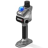
- 1cm High-Precision & 70m Long-Range Scanning: Engineered for demanding terrain and architectural surveying. Equipped with dual 1-inch large-area CMOS sensors delivering 16MP resolution per lens (2.4μm pixel size). It reliably captures spatial data from 0.1 to 40 meters (@ 10% reflectivity) and up to 70 meters (@ 80% reflectivity) for highly accurate 3D mapping.
- 360° LiDAR FOV & Distortion-Free Modeling: Rapidly scan large-area indoor and outdoor spaces in minutes with an expansive 360° × 59° field of view. The built-in mechanical shutter effectively eliminates motion distortion (rolling shutter effect), while dual 16MP ultra-wide cameras (32MP combined) ensure flawless close-range photogrammetry and precise object modeling.
- True-Color Point Cloud with Hardware Sync: Ideal for professional VFX, CGI, and digital twin workflows. Microsecond-level system-wide hardware synchronization ensures perfect alignment of real color and intensity. Combined with global shutter technology, it guarantees the seamless integration of rich color data into highly accurate point clouds.
- Open Algorithm & 3D Gaussian Splatting (3DGS): Designed for advanced, industry-specific pipelines. The system provides raw data accessibility to support custom SLAM algorithm integration, and optimized 3D Gaussian Splatting (3DGS) workflows using precise image pose metadata.
- Complete Software Ecosystem & Multi-Format Export: SHARE Capture and SHARE PointClouds Studio are included for SHARE3DCAM users at no additional software license cost. Preview point clouds in real time on mobile, then process, review, measure, and crop project data on desktop. Export point clouds in PLY, LAS, PCD, E57, and RCS formats, and export CAD floor plan and section drafts as DWG files for downstream CAD and BIM workflows.
A map can represent more than cave shape. Geometry describes surfaces and obstacles; a traversability layer can help distinguish routes the robot may be able to cross; route-planning information can help it choose where to go next. NASA’s Jet Propulsion Laboratory describes topological, semantic and geometrical mapping frameworks for GPS-denied environments, including subsurface caves, as part of its NeBula autonomy architecture.
How do lunar robots map caves in the dark?
Darkness makes ordinary visible-light imaging less dependable, but it does not prevent a robot from measuring the cave. LiDAR sends out laser light and measures the distance to surfaces from the returning signal. Repeated measurements can form a point cloud or other 3D representation of nearby walls, floor and obstacles. ESA’s proposed Würzburg spherical probe concept, for example, names 3D LiDAR and stereo cameras among its mapping tools.
LiDAR is one input, not a complete navigation system. A robot needs to estimate its motion, interpret the map and make safe mobility decisions as well. Cameras may provide visual features when lighting and surfaces allow; inertial measurement can track changes in motion and orientation; radar, contact sensors and other ranging systems can contribute different kinds of evidence.
Windows Errors? Fix Them Before They Spread
Repair common Windows errors and clear accumulated junk for a smoother, more stable PC - no reinstall needed.Free scan · no reinstallCrashes, No Sound, or Screen Glitches?
Random freezes, missing sound and display glitches usually trace back to one bad driver. Find and replace yours safely.Free scan · under a minuteRank #2

- 4K Ultra Imaging
- Up to 100m Scan Range
- 2-Hour Swappable Battery
- 1.1kg Ultra-Light Design
- [Raven Handheld LiDAR Scanner] Designed as an easy-to-use LiDAR scanner for everyone, Raven packs a 50m scanning radius into a pocket-sized body, letting you map entire stadiums in under 5 minutes and capture everything from indoor spaces to larger outdoor environments in minutes.
Why combine sensors?
Every sensing method has conditions in which it may be less useful. A cave robot should not assume that one instrument will work equally well across every surface, lighting condition or obstacle. JPL’s NeBula description identifies vision, an inertial measurement unit (IMU), LiDAR, radar, contact sensors and ranging systems as modalities that its autonomy approach can switch between and fuse according to environmental features. This describes a general strategy—not a claim that all those sensors are installed on a particular lunar cave robot.
Sensor fusion can help keep localization and mapping informed when one source becomes unreliable. It cannot, by itself, ensure that a robot can climb over an obstacle, avoid an unsafe descent or maintain a communication link. Those decisions also depend on the vehicle, mission plan and operating environment.
How would a rover know where it is underground?
It would maintain an onboard estimate, updated from successive sensor observations and checked against the map it is building. In practical terms, the system needs to answer three connected questions: what did the sensors detect, how did the robot move since the last observation, and where do the new observations fit in the existing map?
Rank #3

- 【MicroROS Technology Application】Using MicroROS virtual machine as PC main control, through WiFi-UDP wireless communication, without carrying a bulky computer, the radar data can be wirelessly transmitted to the PC virtual machine. (VM software not support MAC). Support RaspberryPi 5,Jetson Nano,RDK X5 as the main control,which can replace VM and provide complete information.
- 【IMU positioning function and anti-shake reminder】With 6-axis IMU,it plays an important positioning function in map construction.At the same time, in order to prevent the lidar from tilting too much and causing distortion of map data,the research and development cleverly combined IMU to design an anti-shake reminder function.If PALMSLAM tilts in the map, there will be a buzzer alarm prompt (the alarm tilt angle is set after powering on).
- 【Perception enhancement is not limited to the plane】5 lidar versions are available for selection X3PRO/TMINI PLUS/C1/MS200/4ROS,providing precise positioning,scanning frequency, measurement radius data and multi-dimensional information, enhancing perception, not limited to the plane, making the operation more accurate and reliable.if used by beginners, it is recommended to order the Tmini-Plus version.
- 【Support IOS and Android APP】Run the ROS2 system on the PC virtual machine to realize mapping,and cleverly transfer the mapping data to the APP mobile phone through the APP,so that the Palmslam handheld can view the lidar mapping in real time and explore and scan the unscanned areas.
- 【Complete SDK tutorial and support ROS2】Provides compatible handheld mapping, five lidars support ROS2/ROS1, Linux and other document SDK development packages,support ROS and ROS2 operating systems, open Python source code,and provide relevant video tutorials to help customers develop and integrate smoothly across different operating systems and architectures.
- Measure the surroundings. Gather range, visual, inertial or other sensor data that is useful in the local conditions.
- Estimate motion. Use onboard measurements to estimate changes in position and orientation rather than relying on a satellite position fix.
- Update the map. Place observed surfaces and features into a local representation of cave geometry and, where supported, traversability.
- Check for familiar features. When the robot recognizes mapped structure, use it to refine the pose estimate and limit drift.
- Plan and reassess the route. Choose movement based on the map and the robot’s mobility and safety constraints, then repeat the process as new observations arrive.
This is a navigation loop, not a guarantee of continuous certainty. If observations are poor or a route leads to terrain the robot cannot cross, it may need to slow down, choose another path or stop. The exact response depends on the design; the cited sources do not establish a universal lunar-cave navigation procedure or performance level.
What else must a cave mission solve?
Mapping starts well before the robot reaches the cave interior. ESA’s proposed mission baseline begins by scouting a pit rim for a safe access point, then lowering a probe while measuring the pit walls. After reaching the floor, the probe would explore and look for a route into the lava tube. Planetary geologist and speleologist Francesco Sauro described the proposed sequence this way: “The first stage would be to scout out the rim of a pit leading to an underground cave and find a safe place to access it. Then a probe would be deployed into the pit, making measurements of the pit walls as it descends. Finally, the probe would explore the pit floor, find a way to access the lava tube and perform science experiments within the cave to find out more.” The statement appears in ESA’s “En route to exploring lunar caves.”
The approach reflects a broader point: localization and mapping do not make pit entry or cave travel safe on their own. NASA’s 2023 Guidance, Navigation, and Control Technology Assessment identifies cave-entry challenges, irregular and blocky floors, darkness, autonomous localization and operation beyond direct line of sight among the relevant concerns. A mission also needs a way to power its vehicles, communicate with the surface and support its planned environmental measurements.
Rank #4

- 【MicroROS Technology Application】Using MicroROS virtual machine as PC main control, through WiFi-UDP wireless communication, without carrying a bulky computer, the radar data can be wirelessly transmitted to the PC virtual machine. (VM software not support MAC). Support RaspberryPi 5,Jetson Nano,RDK X5 as the main control,which can replace VM and provide complete information.
- 【IMU positioning function and anti-shake reminder】With 6-axis IMU,it plays an important positioning function in map construction.At the same time, in order to prevent the lidar from tilting too much and causing distortion of map data,the research and development cleverly combined IMU to design an anti-shake reminder function.If PALMSLAM tilts in the map, there will be a buzzer alarm prompt (the alarm tilt angle is set after powering on).
- 【Perception enhancement is not limited to the plane】5 lidar versions are available for selection X3PRO/TMINI PLUS/C1/MS200/4ROS,providing precise positioning,scanning frequency, measurement radius data and multi-dimensional information, enhancing perception, not limited to the plane, making the operation more accurate and reliable.if used by beginners, it is recommended to order the Tmini-Plus version.
- 【Support IOS and Android APP】Run the ROS2 system on the PC virtual machine to realize mapping,and cleverly transfer the mapping data to the APP mobile phone through the APP,so that the Palmslam handheld can view the lidar mapping in real time and explore and scan the unscanned areas.
- 【Complete SDK tutorial and support ROS2】Provides compatible handheld mapping, five lidars support ROS2/ROS1, Linux and other document SDK development packages,support ROS and ROS2 operating systems, open Python source code,and provide relevant video tutorials to help customers develop and integrate smoothly across different operating systems and architectures.
What lunar-cave robot concepts have been studied?
ESA has described several approaches as studies or concepts, not as operational lunar robots or finalized mission commitments. Their access methods and support arrangements illustrate different ways a mission might approach the same navigation problem.
| Concept | Access and mobility | Mapping and support | Status and limits |
|---|---|---|---|
| Tethered semi-autonomous rover (DFKI/Bremen study) | A tethered deployment into a tube, with the rover exploring away from the entry. | The tether concept supplies communication and energy. ESA describes mapping in a terrestrial Tenerife lava tube as part of prior work. | A study concept, not a flown lunar system; terrestrial mapping does not demonstrate lunar performance. |
| Spherical probe (Würzburg / Daedalus concept) | Lowered by tether, then able to move independently. | 3D LiDAR and stereo-camera vision are intended to model the cave entrance and initial tube. | A mission concept selected for study, not an operational lunar robot or finalized commitment. |
| Surface crane and cave robots (Oviedo study) | A crane on the surface lowers robots into the cave. | The concept includes a surface solar supply and a charging head intended for wireless power and data transfer. | An investigated concept; the material does not establish it as flight hardware. |
| Cooperative or hopping robots (Manchester study) | Small, agile hopping vehicles are intended for complex terrain. | Networked vehicles would share navigation and mapping data. | A study concept; no lunar cave deployment is established. |
These architectures differ in more than the sensor package. A tether can be part of a communication and energy strategy; a crane can support access and servicing; independent or cooperative vehicles offer different ways to explore. None removes the need to assess descent safety, terrain, available power and communications as part of the mission design.
Recommended Free Tools
What do terrestrial cave tests show—and what do they not show?
NASA’s KNaCK work uses mobile LiDAR and SLAM for mapping and navigation in GPS-denied, unilluminated terrestrial settings, including caves as proving grounds for planetary mapping and navigation. It is relevant evidence that researchers are testing the methods in analogous conditions. It does not establish that a lunar cave robot has flown, or that terrestrial equipment is ready for lunar flight.
Best Value

- 50m Long-Range LiDAR Scanning: Capture large indoor and outdoor environments with a powerful 50-meter scanning radius. Ideal for architecture, construction sites, urban streets, warehouses, stadiums, caves, and landscape mapping projects.
- Advanced SLAM for Stable Spatial Capture: Enhanced SLAM algorithms combine point cloud, image, IMU, and GPS data to reduce drift during movement, delivering smoother alignment and more reliable 3D reconstruction results.
- Professional Accuracy with Ultra-Wide FOV: Featuring up to 2cm accuracy and a 360° × 40° ultra-wide field of view, Raven minimizes blind spots and improves single-pass scanning efficiency in complex environments.
- Stunning 4K True-Color Reconstruction: Single 12MP fisheye cameras automatically adapt to lighting conditions to capture vivid 4K imagery, realistic RGB point clouds, and immersive Gaussian Splatting scenes.
- Lightweight Portable Design: Weighing only 1.1kg, Raven is designed for mobile workflows and field operation. Its compact handheld body makes scanning easier across indoor and outdoor job sites.
Likewise, JPL describes NeBula as an autonomy architecture implemented across terrestrial and planetary-analog missions, with a GPS-free navigation approach for challenging perceptual conditions. That supports the broader robotics approach; it is not evidence of a specific NeBula lunar cave mission. Terrestrial tests do not by themselves demonstrate performance under lunar gravity, vacuum, radiation, temperature extremes, lunar dust behavior, launch loads or a mission’s power budget.
NASA’s Lunar Surface Technology materials also identify cave voids as a development area and describe CADRE as a cooperative mapping demonstration. These are relevant technology-development efforts, but they should not be mistaken for proof that a cave-exploration mission is approved or operating on the Moon.
Can a handheld LiDAR scanner make a 3D cave map?
Handheld LiDAR scanners can provide a terrestrial analogue for how range measurements contribute to 3D mapping. They are not interchangeable with an autonomous lunar robot: a person-operated survey does not demonstrate autonomous localization, safe pit access, cave mobility, lunar-qualified hardware or operation without a direct communication link. The value of the comparison is limited to the mapping principle—using measured distances to represent surrounding surfaces.
The Tool Desk
Outbyte Driver Updater FREEFix the driver behind crashes, sound loss and screen glitchesFind Drivers →Outbyte PC Repair FREEClear out junk files and repair common Windows errorsFree Scan →Quick Recap
Product prices and availability are accurate as of the date/time indicated and are subject to change. Any price and availability information displayed on Amazon at the time of purchase will apply.

