
Recommended Free Tools
iTechGuides is reader-supported. When you buy through links on our site, we may earn an affiliate commission. As an Amazon Associate I earn from qualifying purchases. Learn more
Yes. Amateur astronomers can watch satellites from the ground, and a telescope is not required for a first sighting. The essential tool is a current pass prediction for your location and date. Your eyes are enough for a bright pass; binoculars can make optical detection easier, while photography, measurement, or automatic following require a camera, stable support, accurate timing, current orbital data, and sometimes a tracking mount.
What “tracking a satellite” can mean
The word tracking covers several activities with very different equipment requirements. Decide which outcome you want before buying anything.
Visual spotting
You use a prediction service to learn when and where to look, then watch the sky for a moving point of light. A bright satellite can be visible without optical aid. The object usually looks like a steady light crossing the sky rather than a star fixed in one place. This is the simplest and least expensive form of satellite observing.
Binocular observation
Binoculars provide optical help when a target is faint, the sky is not perfectly dark, or you need to distinguish a moving object from background stars. They are optional for a bright predicted pass. A wide field of view makes it easier to acquire a moving target, while high magnification narrows the view and makes hand-held shaking more noticeable.
#1 Best Overall

- The shell of the equatorial mount is made of PETG and carbon fiber (CF).
- This Equatorial Mount is designed based on an open-source scheme. it uses EESP32S dual-core main control chip. It supports stellar speed, moon speed and custom rotation speed. It also supports switching between the northern and southern hemispheres.
- This Equatorial Mount can be used as a gimbal head for time-lapse photography. No need to download an APP. It is ready to use when it is powered on. And it can be powered by a power bank. Without built-in battery.
- Your gimbal with a standard quick-release plate clamp can be used directly, thanks to a 38mm quick release baseplate at the bottom of the equatorial mount.
- The output shaft is a standard 1/4-inch screw, and a ball head is required for the connection to a camera. Since most of the ball head bottom screw holes are 3/8 inches, please purchase a 1/4 to 3/8 screw sleeve separately.
Photography
Photographing a pass is a separate activity. A digital camera, wide-aperture lens, and stable tripod are the basic components. You must choose a composition and exposure that record the satellite’s motion against the sky; the settings depend on the target, sky brightness, and whether you want a short point-like exposure or a longer trail.
Measurement or active following
Scientific-style work attempts to identify an object, measure its position or brightness, or keep a camera pointed at it as it moves. That work adds accurate time control, current orbital elements, more sensitive cameras or sensors, and software or a mount capable of following the predicted path. It is possible on a modest budget, but it is not the same task as simply seeing a pass.
How a pass prediction tells you where to look
Prediction software propagates a satellite’s orbital elements to estimate its position for a particular observer, date, and time. The result normally includes the beginning and end of a pass, the direction of travel, and the highest altitude or elevation above your horizon. A prediction is therefore the starting point, not an optional extra.
Enter an observing location that is close enough to your actual site. Heavens-Above states that coordinates accurate to about 10 km are adequate for normal satellite observations; events that depend strongly on location need more precise coordinates. Check the service’s time-zone setting before you go outside. The Heavens-Above FAQ says its prediction tables use local time.
A pass is visible only when two conditions overlap: your sky must be dark enough for the object to stand out, and the satellite must still be illuminated by the Sun. This is why useful passes commonly occur during the hours after sunset or before sunrise. At high latitudes, seasonal twilight can leave the sky bright for much longer and change the pattern of visible opportunities.
Rank #2

- ADD GPS FOR THE MOST ACCURATE ALIGNMENT: Upgrade your Celestron computerized telescope with ultra-precise 16-channel GPS time, date, and location data.
- SAVE TIME ALIGNING YOUR SCOPE: Instead of entering the approximate time, date, and location into your hand control manually, SkySync obtains this information from orbiting global positioning satellites, saving you time in the field.
- GREAT FOR ASTROIMAGING: SkySync will improve your alignment—a difference you can see in your astroimages.
- WORKS WITH YOUR EXISTING TELESCOPE: Simply plug into your hand control or any available AUX port on your telescope mount. Work with all non-GPS Celestron computerized telescopes.
- MOUNTING STRAP INCLUDED: We’ve provided a handy Velcro strap to secure the SkySync GPS unit to one of your telescope’s tripod legs, safely out of the way.
A service may omit a pass or show a poor visibility rating because of the satellite’s illumination, expected brightness, local sky conditions, or the orbital elements used for the calculation. Treat the listed time and path as a forecast whose quality depends on current data, not as a guarantee that the object will be obvious.
First observation: a practical procedure
- Choose a prediction service. Open a satellite-pass predictor on a phone or computer and set the observing location. Save the location rather than relying on a generic city center if you observe elsewhere.
- Select a date and pass. Look for an evening or morning opportunity when the sky will be dark while the satellite remains sunlit. Note the start time, end time, direction, and maximum altitude.
- Confirm the clock. Verify whether the table is using local time, daylight-saving time, or another zone. A correct prediction read in the wrong time zone can put you outside at the wrong moment.
- Prepare the view. Go outside several minutes early. Choose a site with an unobstructed horizon in the predicted direction and allow your eyes to adapt to darkness. A dim red light can help you read notes without ruining dark adaptation as quickly as a bright white screen.
- Start with your eyes. Face the predicted part of the sky and scan for a steady moving point. Use the direction and altitude information to limit the area you need to search.
- Add binoculars only if useful. If the object is faint or you are unsure which point is moving, bring binoculars to the region indicated by the prediction. Keep both eyes open if that feels more comfortable and avoid chasing the object with rapid, large movements.
- Record what happened. Note the actual time, direction, cloud cover, and whether the object was visible. These observations help you distinguish a poor prediction from a pass hidden by local conditions or twilight.
The exact path and timing depend on the pass and the age and quality of the orbital data. Do not expect an old prediction to place a satellite precisely, especially after an orbit maneuver.
Crashes, No Sound, or Screen Glitches?
Random freezes, missing sound and display glitches usually trace back to one bad driver. Find and replace yours safely.Free scan · under a minutePC Slower Than It Used to Be?
A free scan shows the junk files, broken settings and background clutter dragging Windows down - then fixes them in one click.Free scan · Windows 10 & 11Equipment matched to your goal
| Goal | Essential equipment | What matters most |
|---|---|---|
| See a bright predicted pass | Pass-prediction service, phone or computer, eyes | Correct location, local time, darkness, and satellite illumination. A telescope is not required. |
| Get optical assistance | Binoculars; a tripod is optional for heavy models | Broad field of view and steadiness. More magnification can make hand-held viewing harder. |
| Photograph a pass | Digital camera, wide-aperture lens, stable tripod | Solid framing, exposure control, and a composition that includes the predicted path. |
| Measure or actively follow a satellite | Camera or sensitive sensor, fast lens or telescope, accurate time reference, current orbital elements, and suitable tracking software or mount | Timing, data quality, calibration, and the ability to keep the target in the instrument’s field. |
Choosing binoculars for satellite observing
NASA’s beginner astronomy guidance gives 7×35 to 10×50 as a practical general range. The first number is magnification; the second is the front-lens diameter in millimetres. Within this range, binoculars remain useful for scanning a reasonably broad patch of sky without the setup burden of a telescope.
Why field of view matters
A satellite moves across the sky, so finding it is often easier with a wider view than with maximum magnification. High-power binoculars show a smaller patch and amplify hand movement. If you cannot hold the image steady, the extra magnification may reduce rather than improve your ability to identify the target.
When a tripod helps
Larger binoculars admit more light but are heavier. NASA cautions that larger, higher-power models are harder to hold steadily. A tripod and binocular adapter can make long observations more comfortable, particularly when you are looking high overhead. This accessory is optional for a simple first attempt.
Rank #3

- Integrated Explore Scientific PMC-Eight system that transcends the industry standard single processor by utilizing eight CPUs that operate independently of one another to focus on defined functions, which results in superior responsiveness, efficiency, reliability and astoundingly fast timing intervals.
- Clutched dual-axis worm gears with quiet precision stepper motor belt drives
- Intuitive ExploreStars app, which is available for Apple, Android and Windows tablets, that makes it simple to operate the GOTO system. Through it, users can quickly align their telescope, navigate the stars and learn specifics about tens of thousands of celestial objects
- Clutched RA and Declination axes are smooth and allow for precise balancing which makes the process of repositioning your telescope efficient
- Polar alignment sight hole through the RA axis and precise altitude control for fast alignment without polar scope.
Why a telescope is not the default choice
A telescope has a narrower field of view and generally requires more setup and aiming skill. It can be valuable for specialized work, but it is not a prerequisite for finding a predicted satellite pass. Buy or borrow one only if you also want to pursue other targets that benefit from higher magnification.
The Tool Desk
Outbyte Driver Updater FREEFix the driver behind crashes, sound loss and screen glitchesFind Drivers →Outbyte PC Repair FREERepair Windows errors before they cause bigger problemsFix Now →Photographing a satellite pass
For a basic trail image, mount a digital camera on a stable tripod and use a lens with a wide aperture. A wide lens makes framing the predicted route easier; a faster aperture allows more light to reach the sensor during a short exposure. Begin with the camera pointed at a recognizable part of the sky and adjust framing and exposure for local conditions.
Photography is not a single standard recipe. Exposure length, focal length, aperture, sensitivity, and focus depend on the satellite’s brightness, the amount of twilight, nearby artificial light, and whether you want a continuous trail or a sequence of positions. Use manual focus on a distant object or the stars when possible, and take test frames before the predicted time.
Do not confuse a long star-trail exposure with active satellite tracking. In a fixed-camera image, the satellite draws a line as it crosses the frame. Active tracking instead attempts to keep the satellite centered and requires a mount or software that can use current orbital predictions.
Equipment for measurement and active tracking
More demanding observations may use sensitive CMOS or CCD cameras, fast lenses, telescopes, accurate timing, and a tracking mount. The NASA SmallSat Institute describes identification and tracking systems as dependent on orbital information; the instrument alone cannot compensate for an incorrect or outdated prediction.
Quick wins for a faster PC:
Repair Windows errors before they cause bigger problemsFix Now →Fix the driver behind crashes, sound loss and screen glitchesFind Drivers →Rank #4
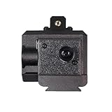
- 🛠 Reinforced Dual-Screw Steel Shaft for Rock-Solid Stability: Built with a thickened steel main axis and a custom dual-screw internal locking system, this star tracker delivers exceptional rigidity with zero loosening under reverse load. Supports 4kg axial load and 2kg lateral load without counterweights, and features a universal 3/8-inch tripod interface for wide camera gear compatibility.
- ✨ High-Brightness Star Pointer for Precision Alignment: The integrated high-brightness star pointer maintains stable output even in -10°C cold weather, allowing accurate polar alignment in demanding outdoor conditions. Simple, reliable, and essential for deep-sky tracking. (Safety Note: Do not point the star pointer at people.)
- ⚡ ESP32 Dual-Core Control with Efficient 5V Power Operation: Powered by the proven ESP32 dual-core microcontroller, this mount offers smooth tracking, responsive control, and excellent energy efficiency. Fully compatible with 5V mobile power banks, making it ideal for long astrophotography sessions in the field.
- 🧩 Carbon Fiber Reinforced PETG Body — Durable & Lightweight: Crafted from carbon fiber–reinforced PETG, the mount surpasses standard PLA in strength, impact resistance, and temperature stability. The refined matte black finish delivers both a premium look and long-lasting outdoor durability.
- 🔍 Hand-Assembled, Calibrated & Quality-Tested: Each unit is individually hand-built, tuned, and tested, ensuring dependable accuracy right out of the box. Comes with a complete accessory package and responsive after-sales support, giving photographers peace of mind for every shooting trip.
Accurate time is important when you compare an observed position with a calculated one. Advanced observers may use GPS-based time control or another reliable reference. You also need a data record that preserves the observation time, location, instrument configuration, and the orbital data used.
Equipment does not have to be expensive to be useful. ESA proceedings attribute this assessment to Marco Langbroek, of Delft Technical University Faculty of Aerospace Engineering: “Meaningful SSA work on earth-orbiting satellites can be done on a shoe-string budget, with modest, off the shelf equipment.” The qualification matters: modest equipment can support meaningful work when the observer applies disciplined timing, identification, and data handling.
Independent reader supportYour contribution helps us test, update, and keep practical guides available for everyone.Orbital elements, TLEs, and data freshness
Pass predictors use orbital elements to calculate where an Earth-orbiting object should appear from your location. JPL’s Horizons documentation accepts user-supplied geocentric SGP4/SDP4 Two-Line Element data for artificial Earth satellites and notes that such data are primarily available from Space-Track and CelesTrak. Horizons also makes clear that the user remains responsible for deciding whether the supplied data are suitable for the intended result.
Do not apply a universal rule such as “a TLE is accurate for exactly X days.” Error depends on the satellite, orbit, maneuvers, element epoch, and whether you are planning a casual visual observation or making a precise measurement. For ordinary viewing, use the newest practical prediction. For measurement, record the element epoch and obtain data from a source and format your software can interpret.
CelesTrak’s GP-format documentation describes a current limitation of the legacy TLE format: its catalog-number field has only five digits, so it cannot represent newly cataloged objects with six-digit catalog numbers. Other general-perturbations formats remove that five-digit restriction. If your target has a six-digit catalog number, confirm that your feed and software support the available format rather than assuming every TLE reader will work.
Best Value

- SUPERIOR STABILITY - The 2" stainless steel tripod legs provide a stable platform, minimizing vibrations for clear, steady views, even at high magnifications, enhancing your observing experience.
- HIGH WEIGHT CAPACITY - Supports up to 30 lbs, accommodating a wide range of telescopes and accessories, ensuring secure and stable operation for various astronomical setups and equipment.
- PRECISE ADJUSTABILITY - Features a latitude adjustment range of 7 to 77 degrees, allowing accurate alignment across different geographical locations for optimal tracking and celestial observation.
- ENHANCED PORTABILITY - With a total kit weight of 47 lbs, the mount and tripod are easily transportable for astronomy enthusiasts who enjoy observing from various locations and dark sky sites.
- ADVANCED TRACKING - Offers sidereal, solar, and lunar tracking rates, along with EQ North and EQ South tracking modes, ensuring accurate and smooth tracking of celestial objects over time.
An older NASA educational answer notes that orbital elements lose accuracy after a few weeks; that is historical guidance, not a promise for every satellite or purpose. For practical planning, use fresh data and treat the required precision as task-dependent. The historical explanation is available at NASA’s night-sky guidance.
Why a predicted pass may be invisible
- Wrong time zone: Recheck the prediction page’s local-time setting and daylight-saving status.
- Bright sky: Civil or seasonal twilight, moonlight, and urban light pollution can overwhelm a faint object even when it is above the horizon.
- Satellite in shadow: A satellite can be geometrically above your horizon but not illuminated by the Sun, making it invisible to reflected-light observers.
- Cloud or haze: Thin cloud can hide a moving point that would be obvious in a clear sky.
- Low elevation: Trees, buildings, and atmospheric extinction are more troublesome near the horizon. Use a pass that climbs higher if one is available.
- Outdated orbital elements: A maneuver or stale element set can shift the predicted path and time. Refresh the data before assuming your eyesight or equipment failed.
- Overly narrow optics: A high-power telescope or binocular may make the target difficult to acquire. Return to unaided viewing or use a wider field.
- Misidentification: Aircraft can blink or change brightness, whereas a typical satellite pass is a steady moving point. Compare the object’s behavior with the predicted direction and timing.
A sensible equipment path for beginners
Start with no optical purchase
Use a current prediction, your phone for timing, your eyes, and a dark location with a clear view. This stage answers the most important question—whether you enjoy the activity—without committing to specialized hardware.
Add general-purpose binoculars
If you want optical assistance, choose a comfortable model in the 7×35 to 10×50 range. Prioritize a field of view you can search easily and a weight you can hold steadily. Add a tripod only if the binoculars are tiring to support by hand.
Add a camera and tripod
For recorded passes, use the camera and wide-aperture lens you already have if they provide manual focus and exposure control. A stable tripod is more important than buying a telescope for this particular goal.
Move to specialized tracking only for a defined project
Before buying a sensitive camera, telescope, or tracking mount, decide whether you need identification, astrometry, photometry, or simply a centered video. Each objective has different requirements for field of view, timing accuracy, calibration, and orbital-data formats.
Bottom line
Amateur satellite tracking is accessible because the essential first step is prediction, not expensive optics. Use current orbital data, choose a pass that is both sunlit and visible against a dark sky, and begin with your eyes. Binoculars in the 7×35 to 10×50 range are a practical optional aid; a camera and tripod are the logical next step for photographs. Measurement and active following are specialized extensions that demand better timing, data discipline, and equipment matched to the required precision.
Quick Recap
Product prices and availability are accurate as of the date/time indicated and are subject to change. Any price and availability information displayed on Amazon at the time of purchase will apply.
Do these 3 things before closing this tab:
1Clear out junk files and repair common Windows errors2Fix the driver behind crashes, sound loss and screen glitches3Repair Windows errors before they cause bigger problems
